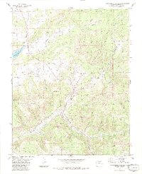
1984 Map of Serviceberry Mountain
USGS Topo · Published 1984About this map
San Juan National Forest covers much of this high-elevation landscape, where the rugged southern Colorado terrain is defined by deep drainages like Echo Canyon and Rito Blanco. The map documents a complex network of water management and early transportation, featuring the Echo Ditch and the Little Blanco Highline Ditch winding along the steep contours. A notable historic corridor is the Old Railroad Grade, which suggests the area's legacy of timber or mineral transport through the mountains north of the New Mexico border.
Find a feature on this map
44 named features on this map. Tap any name to fly to it.
Don’t see what you’re looking for? This feature index may not catch every label — zoom into the map to look around manually.
Map Details
Editions of this 1984 Serviceberry Mountain Map
3 editions found
Other maps of this area

1913 · Summitville
USGS Topo · 1:125,000

1915 · Summitville
USGS Topo · 1:125,000

1924 · Pagosa Springs
USGS Topo · 1:125,000

1927 · Pagosa Springs
USGS Topo · 1:125,000

1945 · Durango
USGS Topo · 1:250,000

1953 · Durango
USGS Topo · 1:250,000

1954 · Durango
USGS Topo · 1:250,000

1957 · Chromo
USGS Topo · 1:62,500

1957 · Wolf Creek Pass
USGS Topo · 1:62,500

1957 · Pagosa Junction
USGS Topo · 1:62,500