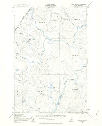
1955 Map of Seven Islands
USGS Topo · Published 1962About this map
The Seven Islands St John River area of northern Maine is captured here as a remote wilderness landscape defined by water and woods during the mid-1950s. This survey, conducted along the international border between Quebec and Maine, reveals a region almost entirely devoid of permanent settlements but heavily shaped by the logging industry. A network of Private roads and Jeep Trails, including the California Road, provides the only access into the backcountry.
Find a feature on this map
39 named features on this map. Tap any name to fly to it.
Don’t see what you’re looking for? This feature index may not catch every label — zoom into the map to look around manually.
Map Details
Editions of this 1955 Seven Islands Map
4 editions found
Other maps of this area

1932 · Umsaskis Lake
USGS Topo · 1:48,000

1935 · Umsaskis Lake
USGS Topo · 1:62,500

1954 · Presque Isle
USGS Topo · 1:250,000

1955 · Rocky Mountain
USGS Topo · 1:62,500

1955 · Little East Lake
USGS Topo · 1:62,500

1955 · Round Pond
USGS Topo · 1:62,500

1955 · Depot Lake
USGS Topo · 1:62,500

1955 · Beaver Pond
USGS Topo · 1:62,500

1955 · Clayton Lake
USGS Topo · 1:62,500

1955 · Seven Islands
USGS Topo · 1:62,500