1984 Map of Seven L Creek East
USGS Topo · Published 1984About this map
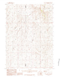
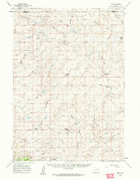
Pine Ridge dominates the northern horizon of this landscape, marking a prominent topographic break in the high plains of eastern Wyoming. This 1984 survey reveals a complex drainage network where seasonal waterways have etched numerous draws and creek beds into the terrain. The border between Natrona Co and Converse Co runs vertically through the center of the sheet, dividing a region defined by its hydrological features rather than town centers. Numerous named ephemeral channels like Charmer Draw, Snake Draw, and Coyote Draw converge toward larger arteries such as Seven L Creek and Shonsy Creek. The density of these named draws and the presence of Sand Spring Creek indicate a landscape where water access dictated movement and land use. This map serves as a primary record of the physical geography of the Powder River Basin area during the late twentieth century.
Find a feature on this map
13 named features on this map. Tap any name to fly to it.
Don’t see what you’re looking for? This feature index may not catch every label — zoom into the map to look around manually.
Map Details
Editions of this 1984 Seven L Creek East Map
This is the sole edition of this map. No revisions or reprints were ever made.
Other maps of this area

1955 · Newcastle
USGS Topo · 1:250,000

1955 · Arminto
USGS Topo · 1:250,000

1958 · Arminto
USGS Topo · 1:250,000

1958 · Newcastle
USGS Topo · 1:250,000
1959 · Fifty-Five Ranch
USGS Topo · 1:62,500
1959 · Edgerton
USGS Topo · 1:62,500
1959 · Ormsby Draw
USGS Topo · 1:62,500
1960 · Ross
USGS Topo · 1:62,500

1962 · Arminto
USGS Topo · 1:250,000
1979 · Bill
USGS Topo · 1:100,000