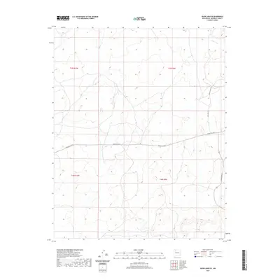
2020 Map of Seven Lakes SE
USGS Topo · Published 2020About this map
Fajada Wash carves through the northeastern corner of this high-desert landscape in the Eastern Navajo Agency, defining the drainage patterns of this McKinley County region. The terrain is structured by a system of service roads and local connectors that facilitate travel across the sparse, arid environment. Principal among these is Navajo Svc Rte 9, which traverses the central portion of the map from east to west. Other essential transit corridors include White Horse Dr and Indian Svc Rte 7017, which provide access to more remote parts of the township. The map provides a clear look at the intersection of modern road infrastructure with traditional land divisions, as evidenced by the grid of the Public Land Survey System. Researchers can observe how the topography influences the placement of routes like Sandspring Rd along the eastern edge.
Find a feature on this map
9 named features on this map. Tap any name to fly to it.
Don’t see what you’re looking for? This feature index may not catch every label — zoom into the map to look around manually.
Map Details
Editions of this 2020 Seven Lakes SE Map
This is the sole edition of this map. No revisions or reprints were ever made.
Other maps of this area

1883 · Mt. Taylor
USGS Topo · 1:250,000

1886 · Mt. Taylor
USGS Topo · 1:250,000

1892 · Mt. Taylor
USGS Topo · 1:250,000

1899 · Mt. Taylor
USGS Topo · 1:250,000

1958 · Albuquerque
USGS Topo · 1:250,000

1961 · Whitehorse
USGS Topo · 1:24,000

1961 · Hospah
USGS Topo · 1:24,000
1961 · Pueblo Pintado
USGS Topo · 1:24,000

1962 · Albuquerque
USGS Topo · 1:250,000
1963 · Laguna Castillo
USGS Topo · 1:24,000