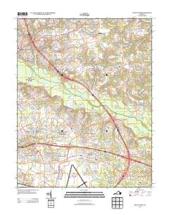
2013 Map of Seven Pines
USGS Topo · Published 2013About this map
The Chickahominy River bisects this landscape, separating the dense suburban growth of eastern Henrico County from the historically significant terrain of Hanover County. This 2013 survey illustrates the modernization of a region defined by its Civil War heritage, where the Cold Harbor Battlefield remains preserved alongside evolving residential developments like Sandston and Fair Oaks. The transportation network is anchored by the Richmond International Airport in the south, while older road traces like Cold Harbor Rd and Mechanicsville Tpke follow paths established long before the era of modern bypasses.
Find a feature on this map
73 named features on this map. Tap any name to fly to it.
Don’t see what you’re looking for? This feature index may not catch every label — zoom into the map to look around manually.
Map Details
Editions of this 2013 Seven Pines Map
This is the sole edition of this map. No revisions or reprints were ever made.
Other maps of this area

1894 · Bermuda Hundred
USGS Topo · 1:62,500

1894 · Richmond
USGS Topo · 1:62,500

1895 · Richmond
USGS Topo · 1:62,500

1918 · Charles City
USGS Topo · 1:62,500

1920 · King William
USGS Topo · 1:62,500

1934 · Seven Pines
USGS Topo · 1:24,000

1934 · Richmond
USGS Topo · 1:24,000

1938 · Dutch Gap
USGS Topo · 1:24,000

1938 · Seven Pines
USGS Topo · 1:31,680

1938 · Drewrys Bluff
USGS Topo · 1:24,000