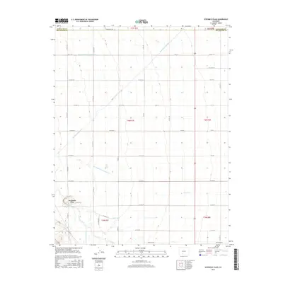
2016 Map of Sevenmile Plaza
USGS Topo · Published 2016About this map
Sevenmile Plaza serves as the focal point of this agricultural landscape in the San Luis Valley, situated just north of the Rio Grande. The area is defined by an intricate network of irrigation systems essential for high-altitude farming, including the Farmers Union Canal and the Monte Vista Canal. These waterways, along with numerous smaller channels like Prairie Ditch and Raney Ditch, illustrate the complex water management required to support the local economy. The grid of rural roads, such as Stoeber Ln and Cottonwood Ln, delineates the land into precise sections typical of the Public Land Survey System. The map also captures the administrative boundary between Saguache and Rio Grande Counties, which runs along the northern edge of this territory. This 2016 survey reflects the enduring reliance on gravity-fed irrigation in one of Colorado's most productive agricultural regions.
Find a feature on this map
48 named features on this map. Tap any name to fly to it.
Don’t see what you’re looking for? This feature index may not catch every label — zoom into the map to look around manually.
Map Details
Editions of this 2016 Sevenmile Plaza Map
This is the sole edition of this map. No revisions or reprints were ever made.
Other maps of this area

1915 · Del Norte
USGS Topo · 1:125,000

1917 · Del Norte
USGS Topo · 1:125,000

1945 · Durango
USGS Topo · 1:250,000

1953 · Durango
USGS Topo · 1:250,000

1954 · Durango
USGS Topo · 1:250,000

1961 · Durango
USGS Topo · 1:250,000

1963 · Durango
USGS Topo · 1:250,000

1964 · Sevenmile Plaza
USGS Topo · 1:24,000

1964 · Monte Vista
USGS Topo · 1:24,000

1966 · Durango
USGS Topo · 1:250,000