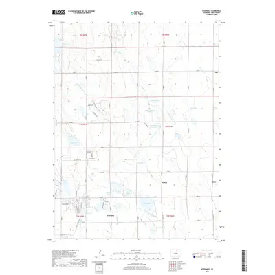
2019 Map of Severance
USGS Topo · Published 2019About this map
Severance serves as the focal point of this Northern Colorado landscape, where an intricate web of irrigation infrastructure supports the region's agricultural productivity. The map documents an extensive network of water management features, including the Eaton Ditch, Pierce Lateral, and Mead Lateral, which feed into numerous storage bodies such as Wykert Reservoir Number 1 and John Law Reservoir. This late 2010s survey captures the intersection of traditional farming water rights with modern residential expansion, evidenced by newer developments near Swanson Lake and the recreational path of the Great Western Trail. Smaller settlements like Hurrich and Gates are visible alongside the town of Ault on the eastern edge. Natural drainage features like Coalbank Cr and The Slough weave between man-made reservoirs like Loup Lake and King Lake, illustrating the sophisticated engineering required to manage water across the Weld County plains.
Find a feature on this map
60 named features on this map. Tap any name to fly to it.
Don’t see what you’re looking for? This feature index may not catch every label — zoom into the map to look around manually.
Map Details
Editions of this 2019 Severance Map
This is the sole edition of this map. No revisions or reprints were ever made.
Other maps of this area

1902 · Greeley
USGS Topo · 1:125,000

1908 · Eaton
USGS Topo · 1:125,000

1910 · Eaton
USGS Topo · 1:125,000

1950 · Greeley
USGS Topo · 1:24,000

1950 · Windsor
USGS Topo · 1:24,000

1950 · Bracewell
USGS Topo · 1:24,000
1951 · Bracewell
USGS Topo · 1:24,000

1954 · Greeley
USGS Topo · 1:250,000

1957 · Greeley
USGS Topo · 1:250,000

1958 · Greeley
USGS Topo · 1:250,000