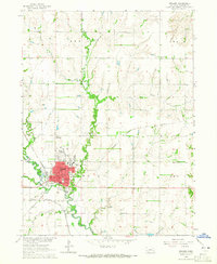
1964 Map of Seward
USGS Topo · Published 1965About this map
Seward serves as the central hub of this 1964 survey, shown during a period of mid-century educational and infrastructure expansion. The campus of Concordia Teachers College and several local institutions like St Johns Sch and High Sch anchor the town's residential core, which is organized around a grid including Main St and Jackson Ave. The surrounding landscape is defined by the winding course of the Big Blue River and its tributaries, Plum Creek and Coon Creek, illustrating the intersection of Nebraska's river-bottom geography with its vital transportation networks. The presence of the Chicago Burlington and Quincy Railroad and an Old Railroad Grade near the Chicago and North Western Railroad tracks highlights the evolving rail economy. Rural education and community life are well-documented through outlying landmarks such as Hells Corner Sch and Union Cem.
Find a feature on this map
43 named features on this map. Tap any name to fly to it.
Don’t see what you’re looking for? This feature index may not catch every label — zoom into the map to look around manually.
Map Details
Editions of this 1964 Seward Map
This is the sole edition of this map. No revisions or reprints were ever made.
Other maps of this area

1897 · Lincoln
USGS Topo · 1:125,000

1899 · Wahoo
USGS Topo · 1:125,000

1899 · David City
USGS Topo · 1:125,000

1934 · Seward
USGS Topo · 1:48,000

1939 · Seward
USGS Topo · 1:62,500

1955 · Fremont
USGS Topo · 1:250,000

1955 · Lincoln
USGS Topo · 1:250,000

1957 · Fremont
USGS Topo · 1:250,000

1957 · Lincoln
USGS Topo · 1:250,000

1958 · Fremont
USGS Topo · 1:250,000