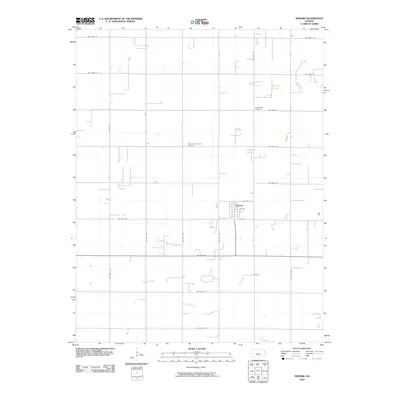
2010 Map of Seward
USGS Topo · Published 2010About this map
Seward serves as the central hub of this agricultural landscape in Stafford County, where a strict section-line road grid defines the rural character. The settlement layout is anchored by 1st St, 5th St, and 8th St, while the surrounding prairie is partitioned by routes such as NW 200th St and NW 60th Ave. This organization reflects the enduring Homestead-era survey patterns that shaped Kansas farming communities. Genealogists can locate two significant burial grounds that speak to the area's early settlement history: Eden Valley Cemetery to the northeast and Saint Francis Xavier Cemetery positioned near the center of the quadrangle. The map documents a landscape of dispersed farmsteads and open spaces, where the orientation of every road and property line adheres to the cardinal directions of the original public land surveys.
Find a feature on this map
22 named features on this map. Tap any name to fly to it.
Don’t see what you’re looking for? This feature index may not catch every label — zoom into the map to look around manually.
Map Details
Editions of this 2010 Seward Map
This is the sole edition of this map. No revisions or reprints were ever made.
Other maps of this area

1891 · Great Bend
USGS Topo · 1:125,000

1893 · Great Bend
USGS Topo · 1:125,000

1955 · Great Bend
USGS Topo · 1:250,000

1957 · Great Bend
USGS Topo · 1:250,000

1957 · Ellinwood SW
USGS Topo · 1:24,000

1958 · Great Bend
USGS Topo · 1:250,000

1958 · Great Bend
USGS Topo · 1:24,000

1960 · Pawnee Rock
USGS Topo · 1:24,000
1969 · Radium
USGS Topo · 1:24,000
1970 · Hudson NW
USGS Topo · 1:24,000