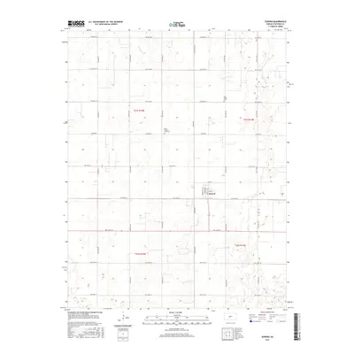
2015 Map of Seward
USGS Topo · Published 2015About this map
The small town of Seward sits at the heart of this Stafford County landscape, serving as a quiet hub for the surrounding agricultural sections. The village grid is defined by streets like Main St and Lincoln Ave, with the local community history anchored by Saint Francis Xavier Cem to the northwest and Eden Valley Cem to the northeast. Beyond the settlement, the terrain is shaped by a dense network of sectional roads such as Larned Rd and Seward Rd, which navigate the subtle drainage of Antelope Cr. The map's layout reflects the enduring Public Land Survey System structure, with township lines like t21s r14w and t21s r13w organizing the prairie into a distinct geometric pattern typical of the Kansas plains.
Find a feature on this map
31 named features on this map. Tap any name to fly to it.
Don’t see what you’re looking for? This feature index may not catch every label — zoom into the map to look around manually.
Map Details
Editions of this 2015 Seward Map
This is the sole edition of this map. No revisions or reprints were ever made.
Other maps of this area

1891 · Great Bend
USGS Topo · 1:125,000

1893 · Great Bend
USGS Topo · 1:125,000

1955 · Great Bend
USGS Topo · 1:250,000

1957 · Great Bend
USGS Topo · 1:250,000

1957 · Ellinwood SW
USGS Topo · 1:24,000

1958 · Great Bend
USGS Topo · 1:250,000

1958 · Great Bend
USGS Topo · 1:24,000

1960 · Pawnee Rock
USGS Topo · 1:24,000
1969 · Radium
USGS Topo · 1:24,000
1970 · Hudson NW
USGS Topo · 1:24,000