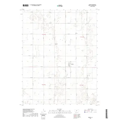
2018 Map of Seward
USGS Topo · Published 2018About this map
Seward serves as the central hub for this Stafford County landscape, where the grid of agricultural roads like Larned Rd and Seward Rd intersect with the community's residential streets. The settlement's layout is clearly defined along Main St and Lincoln Ave, providing a detailed look at the town's structure during the early 21st century. The surrounding countryside is marked by subtle drainage patterns, most notably Antelope Cr in the northern reaches, and the presence of local landmarks such as Saint Francis Xavier Cem and Eden Valley Cem. This 2018 survey captures the persistence of the traditional Kansas township and range system, where section lines dictate the movement of people and commerce between these quiet prairie landmarks.
Find a feature on this map
29 named features on this map. Tap any name to fly to it.
Don’t see what you’re looking for? This feature index may not catch every label — zoom into the map to look around manually.
Map Details
Editions of this 2018 Seward Map
This is the sole edition of this map. No revisions or reprints were ever made.
Other maps of this area

1891 · Great Bend
USGS Topo · 1:125,000

1893 · Great Bend
USGS Topo · 1:125,000

1955 · Great Bend
USGS Topo · 1:250,000

1957 · Great Bend
USGS Topo · 1:250,000

1957 · Ellinwood SW
USGS Topo · 1:24,000

1958 · Great Bend
USGS Topo · 1:250,000

1958 · Great Bend
USGS Topo · 1:24,000

1960 · Pawnee Rock
USGS Topo · 1:24,000
1969 · Radium
USGS Topo · 1:24,000
1970 · Hudson NW
USGS Topo · 1:24,000