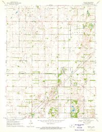
1970 Map of Seward
USGS Topo · Published 1972About this map
The town of Seward serves as the focal point for this Stafford County survey, situated at the intersection of rural transit and resource extraction. The community is anchored by the Missouri Pacific railroad, which cuts diagonally across the township lines of Seward and South Seward. The landscape is defined by its extensive energy infrastructure, with a vast Oil Field and numerous pipelines weaving through the sections of Lincoln and Douglas townships. Notable local landmarks for genealogical research include the Eden Valley Cem and St Francis Xavier Cem, alongside the uniquely labeled Fish Farm in the eastern portion of the quadrangle. The presence of several substations underscores the industrial character of this agricultural and oil-producing region as it appeared in 1970.
Find a feature on this map
14 named features on this map. Tap any name to fly to it.
Don’t see what you’re looking for? This feature index may not catch every label — zoom into the map to look around manually.
Map Details
Editions of this 1970 Seward Map
This is the sole edition of this map. No revisions or reprints were ever made.
Other maps of this area

1891 · Great Bend
USGS Topo · 1:125,000

1893 · Great Bend
USGS Topo · 1:125,000

1955 · Great Bend
USGS Topo · 1:250,000

1957 · Great Bend
USGS Topo · 1:250,000

1957 · Ellinwood SW
USGS Topo · 1:24,000

1958 · Great Bend
USGS Topo · 1:250,000

1958 · Great Bend
USGS Topo · 1:24,000

1960 · Pawnee Rock
USGS Topo · 1:24,000
1969 · Radium
USGS Topo · 1:24,000
1970 · Hudson NW
USGS Topo · 1:24,000