1959 Map of Seward
USGS Topo · Published 1959About this map
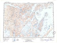
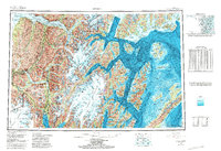
Seward serves as the southern gateway to the interior on this 1950s survey, marking a vital transit point where the Alaska Railroad meets the waters of the Gulf of Alaska. The map traces the complex coastline of Prince William Sound, detailing numerous islands like Knight Island and Latouche Island, the latter of which features the settlement of Latouche. Further north, the connection between the coast and the inland is defined by the rail line passing through Whittier and Portage Junction, while the interior of the Kenai Peninsula is dominated by massive glacial systems including the Harding Icefield and Sargent Icefield. Along the Seward Highway, smaller communities such as Moose Pass, Lawing, and the gold-rush era sites of Hope and Sunrise are documented before the landscape transitions into the high peaks of the Chugach Mountains.
Find a feature on this map
85 named features on this map. Tap any name to fly to it.
Don’t see what you’re looking for? This feature index may not catch every label — zoom into the map to look around manually.
Map Details
Editions of this 1959 Seward Map
This is the sole edition of this map. No revisions or reprints were ever made.
Historical Maps of Seward Through Time
3 maps found