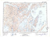
1951 Map of Seward
USGS Topo · Published 1954About this map
Seward serves as the focal point of this mid-century survey, positioned at the head of Resurrection Bay as a vital link between sea and rail. The Alaska Railroad stretches north from the coast, threading through the mountains toward Whittier and Girdwood, illustrating the complex logistical network required to navigate the Kenai Peninsula before the full expansion of modern highways. This era shows a landscape where industrial extraction and settlement are deeply intertwined, with numerous mining operations like the Lucky Strike Mine, Gilpatrick Mine, and Hatcher Mine dotting the drainages of Sixmile Creek and the Resurrection River.
Find a feature on this map
323 named features on this map. Tap any name to fly to it.
Don’t see what you’re looking for? This feature index may not catch every label — zoom into the map to look around manually.
Map Details
Editions of this 1951 Seward Map
4 editions found

Other maps of this area

1944 · Kenai
USGS Topo · 1:250,000

1946 · Blying Sound
USGS Topo · 1:250,000

1948 · Cordova
USGS Topo · 1:250,000

1948 · Middleton Island
USGS Topo · 1:250,000

1949 · Tyonek
USGS Topo · 1:250,000

1950 · Kenai
USGS Topo · 1:250,000

1950 · Middleton Island
USGS Topo · 1:250,000

1950 · Kenai B-1
USGS Topo · 1:63,360

1950 · Seward B-3
USGS Topo · 1:63,360

1950 · Seward A-6
USGS Topo · 1:63,360