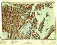
1951 Map of Seward
USGS Topo · Published 1951About this map
Seward serves as the southern anchor of the maritime and rail corridor shown in this mid-century study of the Kenai Peninsula and western Prince William Sound. The Alaska Railroad forms the backbone of the region, winding through the Kenai Mountains from the port at Whittier and the head of Turnagain Arm down to the gulf coast. This period of the territory's history is marked by established coastal settlements like Chenega and Latouche, alongside inland outposts such as Moose Pass and Girdwood.
Find a feature on this map
61 named features on this map. Tap any name to fly to it.
Don’t see what you’re looking for? This feature index may not catch every label — zoom into the map to look around manually.
Map Details
Editions of this 1951 Seward Map
4 editions found

Other maps of this area

1944 · Kenai
USGS Topo · 1:250,000

1946 · Blying Sound
USGS Topo · 1:250,000

1948 · Cordova
USGS Topo · 1:250,000

1948 · Middleton Island
USGS Topo · 1:250,000

1949 · Tyonek
USGS Topo · 1:250,000

1950 · Kenai
USGS Topo · 1:250,000

1950 · Middleton Island
USGS Topo · 1:250,000

1950 · Kenai B-1
USGS Topo · 1:63,360

1950 · Seward B-3
USGS Topo · 1:63,360

1950 · Seward A-6
USGS Topo · 1:63,360