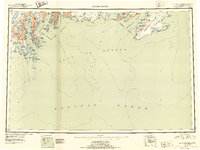
1946 Map of Blying Sound
USGS Topo · Published 1954About this map
The Kenai Mountains dominate this 1940s reconnaissance, a landscape defined by massive ice flows and deep glacial fjords. The Harding Ice Field feeds numerous named glaciers including the Aialik Glacier, Bear Glacier, and Holgate Glacier, which carve into the complex coastline of Aialik Bay and Resurrection Bay. This period of surveying captures the shoreline before later 20th-century shifts, showing the intricate relationship between the mountainous Aialik Peninsula and the open Blying Sound.
Find a feature on this map
63 named features on this map. Tap any name to fly to it.
Don’t see what you’re looking for? This feature index may not catch every label — zoom into the map to look around manually.
Map Details
Editions of this 1946 Blying Sound Map
2 editions found
Historical Maps of Kenai Peninsula Through Time
885 maps found

1946 Blying Sound
Kenai Peninsula Borough, AK

1946 Seldovia C-5
Kenai Peninsula Borough, AK

1946 Seldovia D-5
Kenai Peninsula Borough, AK

1948 Seldovia C-4
Kenai Peninsula Borough, AK

1949 Iliamna C-1
Kenai Peninsula Borough, AK

1949 Seldovia C-4
Kenai Peninsula Borough, AK

1949 Seldovia D-4
Kenai Peninsula Borough, AK

1950 Blying Sound D-4
Kenai Peninsula Borough, AK

1950 Blying Sound D-5
Kenai Peninsula Borough, AK

1950 Blying Sound D-6
Kenai Peninsula Borough, AK

1950 Blying Sound D-7
Kenai Peninsula Borough, AK

1950 Kenai B-1
Kenai Peninsula Borough, AK

1950 Kenai B-3
Kenai Peninsula Borough, AK

1950 Kenai C-3
Kenai Peninsula Borough, AK

1950 Kenai D-4
Kenai Peninsula Borough, AK

1950 Seldovia D-2
Kenai Peninsula Borough, AK

1950 Seward A-6
Kenai Peninsula Borough, AK

1950 Seward A-7
Kenai Peninsula Borough, AK

1950 Seward A-8
Kenai Peninsula Borough, AK

1951 Afognak D-4
Kenai Peninsula Borough, AK

1951 Afognak D-5
Kenai Peninsula Borough, AK

1951 Afognak D-6
Kenai Peninsula Borough, AK

1951 Blying Sound C-8
Kenai Peninsula Borough, AK

1951 Blying Sound D-1 and D-2
Kenai Peninsula Borough, AK

1951 Blying Sound D-7
Kenai Peninsula Borough, AK

1951 Blying Sound D-8
Kenai Peninsula Borough, AK

1951 Blying Sound
Kenai Peninsula Borough, AK

1951 Iliamna A-1 and A-2
Kenai Peninsula Borough, AK

1951 Iliamna A-3
Kenai Peninsula Borough, AK

1951 Iliamna A-4
Kenai Peninsula Borough, AK

1951 Iliamna A-5
Kenai Peninsula Borough, AK

1951 Kenai A-1
Kenai Peninsula Borough, AK

1951 Kenai A-2
Kenai Peninsula Borough, AK

1951 Kenai A-3
Kenai Peninsula Borough, AK

1951 Kenai A-4
Kenai Peninsula Borough, AK

1951 Kenai A-5
Kenai Peninsula Borough, AK

1951 Kenai B-2
Kenai Peninsula Borough, AK

1951 Kenai B-4
Kenai Peninsula Borough, AK

1951 Kenai C-1
Kenai Peninsula Borough, AK

1951 Kenai C-2
Kenai Peninsula Borough, AK

1951 Kenai C-3
Kenai Peninsula Borough, AK

1951 Kenai C-4
Kenai Peninsula Borough, AK

1951 Kenai D-1
Kenai Peninsula Borough, AK

1951 Kenai D-2
Kenai Peninsula Borough, AK

1951 Kenai D-3
Kenai Peninsula Borough, AK

1951 Mount Katmai D-1
Kenai Peninsula Borough, AK

1951 Mount Katmai D-2
Kenai Peninsula Borough, AK

1951 Seldovia A-3
Kenai Peninsula Borough, AK

1951 Seldovia A-4
Kenai Peninsula Borough, AK

1951 Seldovia A-6
Kenai Peninsula Borough, AK

1951 Seldovia B-2
Kenai Peninsula Borough, AK

1951 Seldovia B-3
Kenai Peninsula Borough, AK

1951 Seldovia B-4
Kenai Peninsula Borough, AK

1951 Seldovia B-5
Kenai Peninsula Borough, AK

1951 Seldovia B-6
Kenai Peninsula Borough, AK

1951 Seldovia C-3
Kenai Peninsula Borough, AK

1951 Seldovia C-5
Kenai Peninsula Borough, AK

1951 Seldovia D-1
Kenai Peninsula Borough, AK

1951 Seldovia D-3
Kenai Peninsula Borough, AK

1951 Seldovia D-4
Kenai Peninsula Borough, AK

1951 Seldovia D-5
Kenai Peninsula Borough, AK

1951 Seward A-5
Kenai Peninsula Borough, AK

1951 Seward A-6
Kenai Peninsula Borough, AK

1951 Seward A-7
Kenai Peninsula Borough, AK

1951 Seward A-8
Kenai Peninsula Borough, AK

1951 Seward B-5
Kenai Peninsula Borough, AK

1951 Seward B-6
Kenai Peninsula Borough, AK

1951 Seward B-7
Kenai Peninsula Borough, AK

1951 Seward B-8
Kenai Peninsula Borough, AK

1951 Seward C-5
Kenai Peninsula Borough, AK

1951 Seward C-6
Kenai Peninsula Borough, AK

1951 Seward C-7
Kenai Peninsula Borough, AK

1951 Seward C-8
Kenai Peninsula Borough, AK

1951 Seward D-7
Kenai Peninsula Borough, AK

1951 Seward D-8
Kenai Peninsula Borough, AK

1951 Tyonek A-2
Kenai Peninsula Borough, AK

1952 Blying Sound C-7
Kenai Peninsula Borough, AK

1952 Blying Sound C-8
Kenai Peninsula Borough, AK

1952 Blying Sound D-4
Kenai Peninsula Borough, AK

1952 Blying Sound D-5
Kenai Peninsula Borough, AK

1952 Iliamna A-4
Kenai Peninsula Borough, AK

1952 Iliamna A-5
Kenai Peninsula Borough, AK

1952 Kenai A-1
Kenai Peninsula Borough, AK

1952 Kenai A-2
Kenai Peninsula Borough, AK

1952 Kenai A-3
Kenai Peninsula Borough, AK

1952 Kenai A-4
Kenai Peninsula Borough, AK

1952 Kenai A-5
Kenai Peninsula Borough, AK

1952 Kenai B-1
Kenai Peninsula Borough, AK

1952 Kenai B-2
Kenai Peninsula Borough, AK

1952 Kenai B-3
Kenai Peninsula Borough, AK

1952 Kenai B-4
Kenai Peninsula Borough, AK

1952 Kenai C-1
Kenai Peninsula Borough, AK

1952 Kenai C-2
Kenai Peninsula Borough, AK

1952 Kenai C-3
Kenai Peninsula Borough, AK

1952 Kenai C-4
Kenai Peninsula Borough, AK

1952 Kenai D-1
Kenai Peninsula Borough, AK

1952 Kenai D-2
Kenai Peninsula Borough, AK

1952 Kenai D-3
Kenai Peninsula Borough, AK

1952 Kenai D-4
Kenai Peninsula Borough, AK

1952 Seldovia A-3
Kenai Peninsula Borough, AK

1952 Seldovia A-6
Kenai Peninsula Borough, AK

1952 Seldovia B-3
Kenai Peninsula Borough, AK

1952 Seward A-5
Kenai Peninsula Borough, AK

1952 Seward A-8
Kenai Peninsula Borough, AK

1952 Seward B-5
Kenai Peninsula Borough, AK

1952 Seward B-6
Kenai Peninsula Borough, AK

1952 Seward B-8
Kenai Peninsula Borough, AK

1952 Seward C-5
Kenai Peninsula Borough, AK

1952 Seward C-6
Kenai Peninsula Borough, AK

1952 Seward C-8
Kenai Peninsula Borough, AK

1952 Seward D-7
Kenai Peninsula Borough, AK

1952 Seward D-8
Kenai Peninsula Borough, AK

1952 Tyonek A-2
Kenai Peninsula Borough, AK

1953 Blying Sound D-1 and D-2
Kenai Peninsula Borough, AK

1953 Blying Sound D-3
Kenai Peninsula Borough, AK

1953 Blying Sound D-6
Kenai Peninsula Borough, AK

1953 Blying Sound D-7
Kenai Peninsula Borough, AK

1953 Blying Sound D-8
Kenai Peninsula Borough, AK

1953 Blying Sound
Kenai Peninsula Borough, AK

1953 Mount Katmai D-1
Kenai Peninsula Borough, AK

1953 Seldovia A-4
Kenai Peninsula Borough, AK

1953 Seldovia A-5
Kenai Peninsula Borough, AK

1953 Seldovia B-1
Kenai Peninsula Borough, AK

1953 Seldovia B-2
Kenai Peninsula Borough, AK

1953 Seldovia B-4
Kenai Peninsula Borough, AK

1953 Seldovia B-5
Kenai Peninsula Borough, AK

1953 Seldovia B-6
Kenai Peninsula Borough, AK

1953 Seldovia C-1
Kenai Peninsula Borough, AK

1953 Seldovia C-2
Kenai Peninsula Borough, AK

1953 Seldovia C-3
Kenai Peninsula Borough, AK

1953 Seldovia D-1
Kenai Peninsula Borough, AK

1953 Seldovia D-2
Kenai Peninsula Borough, AK

1953 Seldovia D-3
Kenai Peninsula Borough, AK

1953 Seward B-7
Kenai Peninsula Borough, AK

1953 Seward C-7
Kenai Peninsula Borough, AK

1954 Iliamna B-3
Kenai Peninsula Borough, AK

1954 Iliamna B-4
Kenai Peninsula Borough, AK

1958 Iliamna B-2
Kenai Peninsula Borough, AK

1958 Iliamna C-1
Kenai Peninsula Borough, AK

1958 Iliamna C-2
Kenai Peninsula Borough, AK

1958 Iliamna D-1
Kenai Peninsula Borough, AK

1958 Iliamna D-2
Kenai Peninsula Borough, AK

1958 Kenai A-7
Kenai Peninsula Borough, AK

1958 Kenai A-8
Kenai Peninsula Borough, AK

1958 Kenai B-6
Kenai Peninsula Borough, AK

1958 Kenai B-7
Kenai Peninsula Borough, AK

1958 Kenai B-8
Kenai Peninsula Borough, AK

1958 Kenai C-5
Kenai Peninsula Borough, AK

1958 Kenai C-6
Kenai Peninsula Borough, AK

1958 Kenai C-7
Kenai Peninsula Borough, AK

1958 Kenai C-8
Kenai Peninsula Borough, AK

1958 Kenai D-5
Kenai Peninsula Borough, AK

1958 Kenai D-6
Kenai Peninsula Borough, AK

1958 Kenai D-7
Kenai Peninsula Borough, AK

1958 Kenai D-8
Kenai Peninsula Borough, AK

1958 Lake Clark A-1
Kenai Peninsula Borough, AK

1958 Lake Clark A-2
Kenai Peninsula Borough, AK

1958 Lake Clark B-1
Kenai Peninsula Borough, AK

1958 Lake Clark C-1
Kenai Peninsula Borough, AK

1958 Lake Clark D-1
Kenai Peninsula Borough, AK

1958 Lime Hills A-1
Kenai Peninsula Borough, AK

1958 Lime Hills B-1
Kenai Peninsula Borough, AK

1958 Seldovia D-8
Kenai Peninsula Borough, AK

1958 Tyonek A-3
Kenai Peninsula Borough, AK

1958 Tyonek A-4
Kenai Peninsula Borough, AK

1958 Tyonek A-5
Kenai Peninsula Borough, AK

1958 Tyonek A-6
Kenai Peninsula Borough, AK

1958 Tyonek A-7
Kenai Peninsula Borough, AK

1958 Tyonek A-8
Kenai Peninsula Borough, AK

1958 Tyonek B-5
Kenai Peninsula Borough, AK

1958 Tyonek B-6
Kenai Peninsula Borough, AK

1958 Tyonek B-7
Kenai Peninsula Borough, AK

1958 Tyonek B-8
Kenai Peninsula Borough, AK

1959 Tyonek A-6
Kenai Peninsula Borough, AK

1961 Seldovia C-4
Kenai Peninsula Borough, AK

1961 Seldovia C-5
Kenai Peninsula Borough, AK

1961 Seldovia D-4
Kenai Peninsula Borough, AK

1961 Seldovia D-5
Kenai Peninsula Borough, AK

1981 Seldovia B-4
Kenai Peninsula Borough, AK

1983 Afognak D-6
Kenai Peninsula Borough, AK

1983 Seward A-7 NE
Kenai Peninsula Borough, AK

1983 Seward A-7 NW
Kenai Peninsula Borough, AK

1983 Seward A-7 SE
Kenai Peninsula Borough, AK

1983 Seward A-7 SW
Kenai Peninsula Borough, AK

1983 Seward B-7 NE
Kenai Peninsula Borough, AK

1983 Seward B-7 SE
Kenai Peninsula Borough, AK

1984 Seward D-7 NE
Kenai Peninsula Borough, AK

1984 Seward D-7 NW
Kenai Peninsula Borough, AK

1986 Kenai B-1 NE
Kenai Peninsula Borough, AK

1986 Kenai B-1 NW
Kenai Peninsula Borough, AK

1986 Kenai B-2 NE
Kenai Peninsula Borough, AK

1986 Kenai B-2 NW
Kenai Peninsula Borough, AK

1986 Kenai B-3 NE
Kenai Peninsula Borough, AK

1986 Kenai B-3 NW
Kenai Peninsula Borough, AK

1986 Kenai B-3 SW
Kenai Peninsula Borough, AK

1986 Kenai B-4 NE
Kenai Peninsula Borough, AK

1986 Kenai B-4 NW
Kenai Peninsula Borough, AK

1986 Kenai B-4 SE
Kenai Peninsula Borough, AK

1986 Kenai B-4 SW
Kenai Peninsula Borough, AK

1986 Kenai C-1 NE
Kenai Peninsula Borough, AK

1986 Kenai C-1 NW
Kenai Peninsula Borough, AK

1986 Kenai C-1 SE
Kenai Peninsula Borough, AK

1986 Kenai C-1 SW
Kenai Peninsula Borough, AK

1986 Kenai C-2 NE
Kenai Peninsula Borough, AK

1986 Kenai C-2 NW
Kenai Peninsula Borough, AK

1986 Kenai C-2 SE
Kenai Peninsula Borough, AK

1986 Kenai C-2 SW
Kenai Peninsula Borough, AK

1986 Kenai C-3 NE
Kenai Peninsula Borough, AK

1986 Kenai C-3 NW
Kenai Peninsula Borough, AK

1986 Kenai C-3 SE
Kenai Peninsula Borough, AK

1986 Kenai C-3 SW
Kenai Peninsula Borough, AK

1986 Kenai C-4 NE
Kenai Peninsula Borough, AK

1986 Kenai C-4 NW
Kenai Peninsula Borough, AK

1986 Kenai C-4 SE
Kenai Peninsula Borough, AK

1986 Kenai C-4 SW
Kenai Peninsula Borough, AK

1986 Kenai D-1 NE
Kenai Peninsula Borough, AK

1986 Kenai D-1 NW
Kenai Peninsula Borough, AK

1986 Kenai D-1 SE
Kenai Peninsula Borough, AK

1986 Kenai D-1 SW
Kenai Peninsula Borough, AK

1986 Kenai D-2 NE
Kenai Peninsula Borough, AK

1986 Kenai D-2 NW
Kenai Peninsula Borough, AK

1986 Kenai D-2 SE
Kenai Peninsula Borough, AK

1986 Kenai D-2 SW
Kenai Peninsula Borough, AK

1986 Kenai D-3 NE
Kenai Peninsula Borough, AK

1986 Kenai D-3 SE
Kenai Peninsula Borough, AK

1986 Kenai D-3 SW
Kenai Peninsula Borough, AK

1986 Kenai D-4 SE
Kenai Peninsula Borough, AK

1986 Tyonek A-1 SW
Kenai Peninsula Borough, AK

1986 Tyonek A-2 SE
Kenai Peninsula Borough, AK

1987 Kenai A-4 NE
Kenai Peninsula Borough, AK

1987 Kenai A-4 NW
Kenai Peninsula Borough, AK

1987 Kenai A-4 SW
Kenai Peninsula Borough, AK

1987 Kenai A-5 NE
Kenai Peninsula Borough, AK

1987 Kenai A-5 SE
Kenai Peninsula Borough, AK

1987 Kenai A-5 SW
Kenai Peninsula Borough, AK

1987 Seldovia B-4 NW
Kenai Peninsula Borough, AK

1987 Seldovia B-5 NE
Kenai Peninsula Borough, AK

1987 Seldovia B-5 NW
Kenai Peninsula Borough, AK

1987 Seldovia B-5 SW
Kenai Peninsula Borough, AK

1987 Seldovia B-6 NE
Kenai Peninsula Borough, AK

1987 Seldovia B-6 SE
Kenai Peninsula Borough, AK

1987 Seldovia C-3 NW
Kenai Peninsula Borough, AK

1987 Seldovia C-4 NE
Kenai Peninsula Borough, AK

1987 Seldovia C-4 NW
Kenai Peninsula Borough, AK

1987 Seldovia C-4 SE
Kenai Peninsula Borough, AK

1987 Seldovia C-4 SW
Kenai Peninsula Borough, AK

1987 Seldovia C-5 NE
Kenai Peninsula Borough, AK

1987 Seldovia C-5 NW
Kenai Peninsula Borough, AK

1987 Seldovia C-5 SE
Kenai Peninsula Borough, AK

1987 Seldovia D-3 SW
Kenai Peninsula Borough, AK

1987 Seldovia D-4 SE
Kenai Peninsula Borough, AK

1987 Seldovia D-4 SW
Kenai Peninsula Borough, AK

1987 Seldovia D-5 NE
Kenai Peninsula Borough, AK

1987 Seldovia D-5 NW
Kenai Peninsula Borough, AK

1987 Seldovia D-5 SE
Kenai Peninsula Borough, AK

1987 Seldovia D-5 SW
Kenai Peninsula Borough, AK

1992 Kenai C-1
Kenai Peninsula Borough, AK

1992 Kenai C-2
Kenai Peninsula Borough, AK

1992 Kenai C-3
Kenai Peninsula Borough, AK

1993 Seward D-8 NE
Kenai Peninsula Borough, AK

1994 Seward B-7
Kenai Peninsula Borough, AK

1994 Seward B-8
Kenai Peninsula Borough, AK

1994 Seward C-7
Kenai Peninsula Borough, AK

1994 Seward D-7
Kenai Peninsula Borough, AK

1994 Seward D-8
Kenai Peninsula Borough, AK

1995 Blying Sound D-1 and D-2
Kenai Peninsula Borough, AK

1995 Blying Sound D-3
Kenai Peninsula Borough, AK

1995 Seward A-6
Kenai Peninsula Borough, AK

1995 Seward B-6
Kenai Peninsula Borough, AK

1995 Seward D-8
Kenai Peninsula Borough, AK

1996 Seward B-5
Kenai Peninsula Borough, AK

1996 Seward C-8
Kenai Peninsula Borough, AK

1997 Seward A-7
Kenai Peninsula Borough, AK

1997 Seward C-6
Kenai Peninsula Borough, AK

2013 Tyonek A-4 NE
Kenai Peninsula Borough, AK

2013 Tyonek A-4 NW
Kenai Peninsula Borough, AK

2013 Tyonek A-5 NE
Kenai Peninsula Borough, AK

2013 Tyonek A-5 NW
Kenai Peninsula Borough, AK

2013 Tyonek A-5 SW
Kenai Peninsula Borough, AK

2013 Tyonek B-4 SW
Kenai Peninsula Borough, AK

2013 Tyonek B-5 SE
Kenai Peninsula Borough, AK

2013 Tyonek B-5 SW
Kenai Peninsula Borough, AK

2014 Kenai A-4 NE
Kenai Peninsula Borough, AK

2014 Kenai B-4 SE
Kenai Peninsula Borough, AK

2014 Kenai C-2 NW
Kenai Peninsula Borough, AK

2014 Kenai C-2 SW
Kenai Peninsula Borough, AK

2014 Kenai C-3 NE
Kenai Peninsula Borough, AK

2014 Kenai C-3 NW
Kenai Peninsula Borough, AK

2014 Kenai C-3 SE
Kenai Peninsula Borough, AK

2014 Kenai C-3 SW
Kenai Peninsula Borough, AK

2014 Kenai D-2 SW
Kenai Peninsula Borough, AK

2014 Seldovia D-4 NE
Kenai Peninsula Borough, AK

2014 Seldovia D-5 NE
Kenai Peninsula Borough, AK

2014 Seldovia D-5 SE
Kenai Peninsula Borough, AK

2016 Tyonek A-1 SE
Kenai Peninsula Borough, AK

2016 Tyonek A-1 SW
Kenai Peninsula Borough, AK

2016 Tyonek A-2 SE
Kenai Peninsula Borough, AK

2016 Tyonek A-2 SW
Kenai Peninsula Borough, AK

2016 Tyonek A-3 NW
Kenai Peninsula Borough, AK

2016 Tyonek A-3 SW
Kenai Peninsula Borough, AK

2016 Tyonek A-4 SE
Kenai Peninsula Borough, AK

2016 Tyonek A-4 SW
Kenai Peninsula Borough, AK

2016 Tyonek A-5 SE
Kenai Peninsula Borough, AK

2016 Tyonek A-6 NE
Kenai Peninsula Borough, AK

2016 Tyonek A-6 NW
Kenai Peninsula Borough, AK

2016 Tyonek A-6 SE
Kenai Peninsula Borough, AK

2016 Tyonek A-6 SW
Kenai Peninsula Borough, AK

2016 Tyonek A-7 NE
Kenai Peninsula Borough, AK

2016 Tyonek A-7 SE
Kenai Peninsula Borough, AK

2016 Tyonek B-6 SE
Kenai Peninsula Borough, AK

2017 Blying Sound C-7 NW
Kenai Peninsula Borough, AK

2017 Blying Sound C-8 NE
Kenai Peninsula Borough, AK

2017 Blying Sound C-8 NW
Kenai Peninsula Borough, AK

2017 Blying Sound C-8 SE
Kenai Peninsula Borough, AK

2017 Blying Sound D-6 NE
Kenai Peninsula Borough, AK

2017 Blying Sound D-6 NW
Kenai Peninsula Borough, AK

2017 Blying Sound D-7 NE
Kenai Peninsula Borough, AK

2017 Blying Sound D-7 NW
Kenai Peninsula Borough, AK

2017 Blying Sound D-7 SE
Kenai Peninsula Borough, AK

2017 Blying Sound D-7 SW
Kenai Peninsula Borough, AK

2017 Blying Sound D-8 NE
Kenai Peninsula Borough, AK

2017 Blying Sound D-8 NW
Kenai Peninsula Borough, AK

2017 Blying Sound D-8 SE
Kenai Peninsula Borough, AK

2017 Blying Sound D-8 SW
Kenai Peninsula Borough, AK

2017 Kenai A-1 NE
Kenai Peninsula Borough, AK

2017 Kenai A-1 NW
Kenai Peninsula Borough, AK

2017 Kenai A-1 SE
Kenai Peninsula Borough, AK

2017 Kenai A-1 SW
Kenai Peninsula Borough, AK

2017 Kenai A-2 NE
Kenai Peninsula Borough, AK

2017 Kenai A-2 NW
Kenai Peninsula Borough, AK

2017 Kenai A-2 SE
Kenai Peninsula Borough, AK

2017 Kenai A-2 SW
Kenai Peninsula Borough, AK

2017 Kenai A-3 NE
Kenai Peninsula Borough, AK

2017 Kenai A-3 SE
Kenai Peninsula Borough, AK

2017 Kenai A-8 NE
Kenai Peninsula Borough, AK

2017 Kenai A-8 NW
Kenai Peninsula Borough, AK

2017 Kenai A-8 SE
Kenai Peninsula Borough, AK

2017 Kenai A-8 SW
Kenai Peninsula Borough, AK

2017 Kenai B-1 NE
Kenai Peninsula Borough, AK

2017 Kenai B-1 NW
Kenai Peninsula Borough, AK

2017 Kenai B-1 SE
Kenai Peninsula Borough, AK

2017 Kenai B-1 SW
Kenai Peninsula Borough, AK

2017 Kenai B-2 NE
Kenai Peninsula Borough, AK

2017 Kenai B-2 NW
Kenai Peninsula Borough, AK

2017 Kenai B-2 SE
Kenai Peninsula Borough, AK

2017 Kenai B-2 SW
Kenai Peninsula Borough, AK

2017 Kenai B-3 NE
Kenai Peninsula Borough, AK

2017 Kenai B-3 SE
Kenai Peninsula Borough, AK

2017 Kenai B-6 NW
Kenai Peninsula Borough, AK

2017 Kenai B-6 SW
Kenai Peninsula Borough, AK

2017 Kenai B-7 NE
Kenai Peninsula Borough, AK

2017 Kenai B-7 NW
Kenai Peninsula Borough, AK

2017 Kenai B-7 SE
Kenai Peninsula Borough, AK

2017 Kenai B-7 SW
Kenai Peninsula Borough, AK

2017 Kenai B-8 NE
Kenai Peninsula Borough, AK

2017 Kenai B-8 NW
Kenai Peninsula Borough, AK

2017 Kenai B-8 SE
Kenai Peninsula Borough, AK

2017 Kenai B-8 SW
Kenai Peninsula Borough, AK

2017 Kenai C-1 NE
Kenai Peninsula Borough, AK

2017 Kenai C-1 NW
Kenai Peninsula Borough, AK

2017 Kenai C-1 SE
Kenai Peninsula Borough, AK

2017 Kenai C-1 SW
Kenai Peninsula Borough, AK

2017 Kenai C-2 NE
Kenai Peninsula Borough, AK

2017 Kenai C-2 SE
Kenai Peninsula Borough, AK

2017 Kenai C-6 NW
Kenai Peninsula Borough, AK

2017 Kenai C-6 SW
Kenai Peninsula Borough, AK

2017 Kenai C-7 NE
Kenai Peninsula Borough, AK

2017 Kenai C-7 NW
Kenai Peninsula Borough, AK

2017 Kenai C-7 SE
Kenai Peninsula Borough, AK

2017 Kenai C-7 SW
Kenai Peninsula Borough, AK

2017 Kenai C-8 NE
Kenai Peninsula Borough, AK

2017 Kenai C-8 NW
Kenai Peninsula Borough, AK

2017 Kenai C-8 SE
Kenai Peninsula Borough, AK

2017 Kenai C-8 SW
Kenai Peninsula Borough, AK

2017 Kenai D-1 NE
Kenai Peninsula Borough, AK

2017 Kenai D-1 NW
Kenai Peninsula Borough, AK

2017 Kenai D-1 SE
Kenai Peninsula Borough, AK

2017 Kenai D-1 SW
Kenai Peninsula Borough, AK

2017 Kenai D-2 NE
Kenai Peninsula Borough, AK

2017 Kenai D-2 NW
Kenai Peninsula Borough, AK

2017 Kenai D-2 SE
Kenai Peninsula Borough, AK

2017 Kenai D-3 NE
Kenai Peninsula Borough, AK

2017 Kenai D-3 SE
Kenai Peninsula Borough, AK

2017 Kenai D-6 NW
Kenai Peninsula Borough, AK

2017 Kenai D-6 SW
Kenai Peninsula Borough, AK

2017 Kenai D-7 NE
Kenai Peninsula Borough, AK

2017 Kenai D-7 NW
Kenai Peninsula Borough, AK

2017 Kenai D-7 SE
Kenai Peninsula Borough, AK

2017 Kenai D-7 SW
Kenai Peninsula Borough, AK

2017 Kenai D-8 NE
Kenai Peninsula Borough, AK

2017 Kenai D-8 NW
Kenai Peninsula Borough, AK

2017 Kenai D-8 SE
Kenai Peninsula Borough, AK

2017 Kenai D-8 SW
Kenai Peninsula Borough, AK

2017 Lime Hills A-1 SE
Kenai Peninsula Borough, AK

2017 Lime Hills B-1 SE
Kenai Peninsula Borough, AK

2017 Seldovia A-3 NE
Kenai Peninsula Borough, AK

2017 Seldovia B-1 NW
Kenai Peninsula Borough, AK

2017 Seldovia B-1 SW
Kenai Peninsula Borough, AK

2017 Seldovia B-2 NE
Kenai Peninsula Borough, AK

2017 Seldovia B-2 NW
Kenai Peninsula Borough, AK

2017 Seldovia B-2 SE
Kenai Peninsula Borough, AK

2017 Seldovia B-2 SW
Kenai Peninsula Borough, AK

2017 Seldovia B-3 NE
Kenai Peninsula Borough, AK

2017 Seldovia B-3 SE
Kenai Peninsula Borough, AK

2017 Seldovia C-1 NE
Kenai Peninsula Borough, AK

2017 Seldovia C-1 NW
Kenai Peninsula Borough, AK

2017 Seldovia C-1 SE
Kenai Peninsula Borough, AK

2017 Seldovia C-1 SW
Kenai Peninsula Borough, AK

2017 Seldovia C-2 NE
Kenai Peninsula Borough, AK

2017 Seldovia C-2 NW
Kenai Peninsula Borough, AK

2017 Seldovia C-2 SE
Kenai Peninsula Borough, AK

2017 Seldovia C-2 SW
Kenai Peninsula Borough, AK

2017 Seldovia C-3 NE
Kenai Peninsula Borough, AK

2017 Seldovia C-3 SE
Kenai Peninsula Borough, AK

2017 Seldovia D-1 NE
Kenai Peninsula Borough, AK

2017 Seldovia D-1 NW
Kenai Peninsula Borough, AK

2017 Seldovia D-1 SE
Kenai Peninsula Borough, AK

2017 Seldovia D-1 SW
Kenai Peninsula Borough, AK

2017 Seldovia D-2 NE
Kenai Peninsula Borough, AK

2017 Seldovia D-2 NW
Kenai Peninsula Borough, AK

2017 Seldovia D-2 SE
Kenai Peninsula Borough, AK

2017 Seldovia D-2 SW
Kenai Peninsula Borough, AK

2017 Seldovia D-3 NE
Kenai Peninsula Borough, AK

2017 Seldovia D-3 SE
Kenai Peninsula Borough, AK

2017 Seward A-6 SE
Kenai Peninsula Borough, AK

2017 Seward A-6 SW
Kenai Peninsula Borough, AK

2017 Seward A-7 SE
Kenai Peninsula Borough, AK

2017 Seward A-7 SW
Kenai Peninsula Borough, AK

2017 Seward A-8 SE
Kenai Peninsula Borough, AK

2017 Seward A-8 SW
Kenai Peninsula Borough, AK

2017 Seward B-8 NW
Kenai Peninsula Borough, AK

2017 Seward B-8 SW
Kenai Peninsula Borough, AK

2017 Seward C-8 NW
Kenai Peninsula Borough, AK

2017 Seward C-8 SW
Kenai Peninsula Borough, AK

2017 Seward D-7 NE
Kenai Peninsula Borough, AK

2017 Seward D-8 NW
Kenai Peninsula Borough, AK

2017 Seward D-8 SW
Kenai Peninsula Borough, AK

2017 Tyonek A-7 NW
Kenai Peninsula Borough, AK

2017 Tyonek A-7 SW
Kenai Peninsula Borough, AK

2017 Tyonek A-8 NE
Kenai Peninsula Borough, AK

2017 Tyonek A-8 NW
Kenai Peninsula Borough, AK

2017 Tyonek A-8 SE
Kenai Peninsula Borough, AK

2017 Tyonek A-8 SW
Kenai Peninsula Borough, AK

2017 Tyonek B-6 SW
Kenai Peninsula Borough, AK

2017 Tyonek B-7 SE
Kenai Peninsula Borough, AK

2017 Tyonek B-7 SW
Kenai Peninsula Borough, AK

2017 Tyonek B-8 SE
Kenai Peninsula Borough, AK

2017 Tyonek B-8 SW
Kenai Peninsula Borough, AK

2018 Blying Sound C-7 SW
Kenai Peninsula Borough, AK

2018 Blying Sound C-8 SW
Kenai Peninsula Borough, AK

2018 Blying Sound D-1 NW
Kenai Peninsula Borough, AK

2018 Blying Sound D-1 SW
Kenai Peninsula Borough, AK

2018 Blying Sound D-2 NE
Kenai Peninsula Borough, AK

2018 Blying Sound D-2 NW
Kenai Peninsula Borough, AK

2018 Blying Sound D-2 SE
Kenai Peninsula Borough, AK

2018 Blying Sound D-2 SW
Kenai Peninsula Borough, AK

2018 Blying Sound D-3 NE
Kenai Peninsula Borough, AK

2018 Blying Sound D-3 NW
Kenai Peninsula Borough, AK

2018 Blying Sound D-3 SE
Kenai Peninsula Borough, AK

2018 Blying Sound D-4 NE
Kenai Peninsula Borough, AK

2018 Blying Sound D-4 NW
Kenai Peninsula Borough, AK

2018 Blying Sound D-5 NE
Kenai Peninsula Borough, AK

2018 Blying Sound D-5 NW
Kenai Peninsula Borough, AK

2018 Iliamna A-1 NW
Kenai Peninsula Borough, AK

2018 Iliamna A-1 SW
Kenai Peninsula Borough, AK

2018 Iliamna A-2 SE
Kenai Peninsula Borough, AK

2018 Iliamna A-2 SW
Kenai Peninsula Borough, AK

2018 Iliamna A-3 SE
Kenai Peninsula Borough, AK

2018 Iliamna A-4 NE
Kenai Peninsula Borough, AK

2018 Iliamna A-4 NW
Kenai Peninsula Borough, AK

2018 Iliamna A-4 SE
Kenai Peninsula Borough, AK

2018 Iliamna A-4 SW
Kenai Peninsula Borough, AK

2018 Iliamna A-5 NE
Kenai Peninsula Borough, AK

2018 Iliamna A-5 SE
Kenai Peninsula Borough, AK

2018 Iliamna B-2 NE
Kenai Peninsula Borough, AK

2018 Iliamna B-2 NW
Kenai Peninsula Borough, AK

2018 Iliamna B-2 OE E NW
Kenai Peninsula Borough, AK

2018 Iliamna B-2 OE E SW
Kenai Peninsula Borough, AK

2018 Iliamna B-2 SE
Kenai Peninsula Borough, AK

2018 Iliamna B-2 SW
Kenai Peninsula Borough, AK

2018 Iliamna B-3 NE
Kenai Peninsula Borough, AK

2018 Iliamna B-3 SE
Kenai Peninsula Borough, AK

2018 Iliamna B-4 SE
Kenai Peninsula Borough, AK

2018 Iliamna B-4 SW
Kenai Peninsula Borough, AK

2018 Iliamna C-1 NE
Kenai Peninsula Borough, AK

2018 Iliamna C-1 NW
Kenai Peninsula Borough, AK

2018 Iliamna C-1 SW
Kenai Peninsula Borough, AK

2018 Iliamna C-2 NE
Kenai Peninsula Borough, AK

2018 Iliamna C-2 NW
Kenai Peninsula Borough, AK

2018 Iliamna C-2 SE
Kenai Peninsula Borough, AK

2018 Iliamna C-2 SW
Kenai Peninsula Borough, AK

2018 Iliamna C-3 NE
Kenai Peninsula Borough, AK

2018 Iliamna C-3 SE
Kenai Peninsula Borough, AK

2018 Iliamna D-1 NE
Kenai Peninsula Borough, AK

2018 Iliamna D-1 NW
Kenai Peninsula Borough, AK

2018 Iliamna D-1 SE
Kenai Peninsula Borough, AK

2018 Iliamna D-1 SW
Kenai Peninsula Borough, AK

2018 Iliamna D-2 NE
Kenai Peninsula Borough, AK

2018 Iliamna D-2 NW
Kenai Peninsula Borough, AK

2018 Iliamna D-2 SE
Kenai Peninsula Borough, AK

2018 Iliamna D-2 SW
Kenai Peninsula Borough, AK

2018 Kenai A-3 NW
Kenai Peninsula Borough, AK

2018 Kenai A-3 SW
Kenai Peninsula Borough, AK

2018 Kenai A-4 NW
Kenai Peninsula Borough, AK

2018 Kenai A-4 SE
Kenai Peninsula Borough, AK

2018 Kenai A-4 SW
Kenai Peninsula Borough, AK

2018 Kenai A-5 NE
Kenai Peninsula Borough, AK

2018 Kenai A-5 SE
Kenai Peninsula Borough, AK

2018 Kenai A-5 SW
Kenai Peninsula Borough, AK

2018 Kenai A-7 NW
Kenai Peninsula Borough, AK

2018 Kenai A-7 SW
Kenai Peninsula Borough, AK

2018 Kenai B-3 NW
Kenai Peninsula Borough, AK

2018 Kenai B-3 SW
Kenai Peninsula Borough, AK

2018 Kenai B-4 NE
Kenai Peninsula Borough, AK

2018 Kenai B-4 NW
Kenai Peninsula Borough, AK

2018 Kenai B-4 SW
Kenai Peninsula Borough, AK

2018 Kenai B-6 NE
Kenai Peninsula Borough, AK

2018 Kenai B-6 OE E NW
Kenai Peninsula Borough, AK

2018 Kenai B-6 SE
Kenai Peninsula Borough, AK

2018 Kenai C-4 NE
Kenai Peninsula Borough, AK

2018 Kenai C-4 NW
Kenai Peninsula Borough, AK

2018 Kenai C-4 SE
Kenai Peninsula Borough, AK

2018 Kenai C-4 SW
Kenai Peninsula Borough, AK

2018 Kenai C-5 NW
Kenai Peninsula Borough, AK

2018 Kenai C-5 SW
Kenai Peninsula Borough, AK

2018 Kenai C-6 NE
Kenai Peninsula Borough, AK

2018 Kenai C-6 SE
Kenai Peninsula Borough, AK

2018 Kenai D-3 NW
Kenai Peninsula Borough, AK

2018 Kenai D-3 SW
Kenai Peninsula Borough, AK

2018 Kenai D-4 SE
Kenai Peninsula Borough, AK

2018 Kenai D-5 NE
Kenai Peninsula Borough, AK

2018 Kenai D-5 NW
Kenai Peninsula Borough, AK

2018 Kenai D-5 SW
Kenai Peninsula Borough, AK

2018 Kenai D-6 NE
Kenai Peninsula Borough, AK

2018 Kenai D-6 SE
Kenai Peninsula Borough, AK

2018 Lake Clark A-1 NE
Kenai Peninsula Borough, AK

2018 Lake Clark A-1 NW
Kenai Peninsula Borough, AK

2018 Lake Clark A-1 SE
Kenai Peninsula Borough, AK

2018 Lake Clark A-1 SW
Kenai Peninsula Borough, AK

2018 Lake Clark A-2 NE
Kenai Peninsula Borough, AK

2018 Lake Clark A-2 SE
Kenai Peninsula Borough, AK

2018 Lake Clark B-1 NE
Kenai Peninsula Borough, AK

2018 Lake Clark B-1 NW
Kenai Peninsula Borough, AK

2018 Lake Clark B-1 SE
Kenai Peninsula Borough, AK

2018 Lake Clark B-1 SW
Kenai Peninsula Borough, AK

2018 Lake Clark B-2 NE
Kenai Peninsula Borough, AK

2018 Lake Clark B-2 SE
Kenai Peninsula Borough, AK

2018 Lake Clark C-1 NE
Kenai Peninsula Borough, AK

2018 Lake Clark C-1 NW
Kenai Peninsula Borough, AK

2018 Lake Clark C-1 SE
Kenai Peninsula Borough, AK

2018 Lake Clark C-1 SW
Kenai Peninsula Borough, AK

2018 Lake Clark D-1 NE
Kenai Peninsula Borough, AK

2018 Lake Clark D-1 NW
Kenai Peninsula Borough, AK

2018 Lake Clark D-1 SE
Kenai Peninsula Borough, AK

2018 Lake Clark D-1 SW
Kenai Peninsula Borough, AK

2018 Seldovia A-3 NW
Kenai Peninsula Borough, AK

2018 Seldovia A-4 NE
Kenai Peninsula Borough, AK

2018 Seldovia A-4 NW
Kenai Peninsula Borough, AK

2018 Seldovia A-4 SW
Kenai Peninsula Borough, AK

2018 Seldovia A-5 NE
Kenai Peninsula Borough, AK

2018 Seldovia A-5 NW
Kenai Peninsula Borough, AK

2018 Seldovia A-5 SE
Kenai Peninsula Borough, AK

2018 Seldovia A-5 SW
Kenai Peninsula Borough, AK

2018 Seldovia A-6 NE
Kenai Peninsula Borough, AK

2018 Seldovia B-3 NW
Kenai Peninsula Borough, AK

2018 Seldovia B-3 SW
Kenai Peninsula Borough, AK

2018 Seldovia B-4 NE
Kenai Peninsula Borough, AK

2018 Seldovia B-4 NW
Kenai Peninsula Borough, AK

2018 Seldovia B-4 SE
Kenai Peninsula Borough, AK

2018 Seldovia B-4 SW
Kenai Peninsula Borough, AK

2018 Seldovia B-5 NE
Kenai Peninsula Borough, AK

2018 Seldovia B-5 NW
Kenai Peninsula Borough, AK

2018 Seldovia B-5 SE
Kenai Peninsula Borough, AK

2018 Seldovia B-5 SW
Kenai Peninsula Borough, AK

2018 Seldovia B-6 NE
Kenai Peninsula Borough, AK

2018 Seldovia B-6 SE
Kenai Peninsula Borough, AK

2018 Seldovia C-3 NW
Kenai Peninsula Borough, AK

2018 Seldovia C-3 SW
Kenai Peninsula Borough, AK

2018 Seldovia C-4 NE
Kenai Peninsula Borough, AK

2018 Seldovia C-4 NW
Kenai Peninsula Borough, AK

2018 Seldovia C-4 SE
Kenai Peninsula Borough, AK

2018 Seldovia C-4 SW
Kenai Peninsula Borough, AK

2018 Seldovia C-5 NE
Kenai Peninsula Borough, AK

2018 Seldovia C-5 NW
Kenai Peninsula Borough, AK

2018 Seldovia C-5 SE
Kenai Peninsula Borough, AK

2018 Seldovia D-3 NW
Kenai Peninsula Borough, AK

2018 Seldovia D-3 SW
Kenai Peninsula Borough, AK

2018 Seldovia D-4 NW
Kenai Peninsula Borough, AK

2018 Seldovia D-4 SE
Kenai Peninsula Borough, AK

2018 Seldovia D-4 SW
Kenai Peninsula Borough, AK

2018 Seldovia D-5 NW
Kenai Peninsula Borough, AK

2018 Seldovia D-5 SW
Kenai Peninsula Borough, AK

2018 Seward A-5 NE
Kenai Peninsula Borough, AK

2018 Seward A-5 NW
Kenai Peninsula Borough, AK

2018 Seward A-5 SE
Kenai Peninsula Borough, AK

2018 Seward A-5 SW
Kenai Peninsula Borough, AK

2018 Seward A-6 NE
Kenai Peninsula Borough, AK

2018 Seward A-6 NW
Kenai Peninsula Borough, AK

2018 Seward A-7 NE
Kenai Peninsula Borough, AK

2018 Seward A-7 NW
Kenai Peninsula Borough, AK

2018 Seward A-8 NE
Kenai Peninsula Borough, AK

2018 Seward A-8 NW
Kenai Peninsula Borough, AK

2018 Seward B-5 NE
Kenai Peninsula Borough, AK

2018 Seward B-5 NW
Kenai Peninsula Borough, AK

2018 Seward B-5 SE
Kenai Peninsula Borough, AK

2018 Seward B-5 SW
Kenai Peninsula Borough, AK

2018 Seward B-6 NE
Kenai Peninsula Borough, AK

2018 Seward B-6 NW
Kenai Peninsula Borough, AK

2018 Seward B-6 SE
Kenai Peninsula Borough, AK

2018 Seward B-6 SW
Kenai Peninsula Borough, AK

2018 Seward B-7 NE
Kenai Peninsula Borough, AK

2018 Seward B-7 NW
Kenai Peninsula Borough, AK

2018 Seward B-7 SE
Kenai Peninsula Borough, AK

2018 Seward B-7 SW
Kenai Peninsula Borough, AK

2018 Seward B-8 NE
Kenai Peninsula Borough, AK

2018 Seward B-8 SE
Kenai Peninsula Borough, AK

2018 Seward C-5 NE
Kenai Peninsula Borough, AK

2018 Seward C-5 NW
Kenai Peninsula Borough, AK

2018 Seward C-5 SE
Kenai Peninsula Borough, AK

2018 Seward C-5 SW
Kenai Peninsula Borough, AK

2018 Seward C-6 NE
Kenai Peninsula Borough, AK

2018 Seward C-6 NW
Kenai Peninsula Borough, AK

2018 Seward C-6 SE
Kenai Peninsula Borough, AK

2018 Seward C-6 SW
Kenai Peninsula Borough, AK

2018 Seward C-7 NE
Kenai Peninsula Borough, AK

2018 Seward C-7 NW
Kenai Peninsula Borough, AK

2018 Seward C-7 SE
Kenai Peninsula Borough, AK

2018 Seward C-7 SW
Kenai Peninsula Borough, AK

2018 Seward C-8 NE
Kenai Peninsula Borough, AK

2018 Seward C-8 SE
Kenai Peninsula Borough, AK

2018 Seward D-6 SW
Kenai Peninsula Borough, AK

2018 Seward D-7 NW
Kenai Peninsula Borough, AK

2018 Seward D-7 SE
Kenai Peninsula Borough, AK

2018 Seward D-7 SW
Kenai Peninsula Borough, AK

2018 Seward D-8 NE
Kenai Peninsula Borough, AK

2018 Seward D-8 SE
Kenai Peninsula Borough, AK

2019 Afognak D-4 NW
Kenai Peninsula Borough, AK

2019 Afognak D-5 NE
Kenai Peninsula Borough, AK

2019 Afognak D-5 NW
Kenai Peninsula Borough, AK

2019 Afognak D-6 NE
Kenai Peninsula Borough, AK

2019 Afognak D-6 NW
Kenai Peninsula Borough, AK

2019 Afognak D-6 SE
Kenai Peninsula Borough, AK

2019 Afognak D-6 SW
Kenai Peninsula Borough, AK

2019 Lime Hills A-1 NE
Kenai Peninsula Borough, AK

2019 Lime Hills A-1 NW
Kenai Peninsula Borough, AK

2019 Lime Hills A-1 SE
Kenai Peninsula Borough, AK

2019 Lime Hills A-1 SW
Kenai Peninsula Borough, AK

2019 Lime Hills A-2 NE
Kenai Peninsula Borough, AK

2019 Lime Hills B-1 SE
Kenai Peninsula Borough, AK

2019 Lime Hills B-1 SW
Kenai Peninsula Borough, AK

2019 Lime Hills B-2 SE
Kenai Peninsula Borough, AK

2019 Mount Katmai C-1 NE
Kenai Peninsula Borough, AK

2019 Mount Katmai C-1 NW
Kenai Peninsula Borough, AK

2019 Mount Katmai C-2 NE
Kenai Peninsula Borough, AK

2019 Mount Katmai C-2 NW
Kenai Peninsula Borough, AK

2019 Mount Katmai D-1 NE
Kenai Peninsula Borough, AK

2019 Mount Katmai D-1 NW
Kenai Peninsula Borough, AK

2019 Mount Katmai D-1 SE
Kenai Peninsula Borough, AK

2019 Mount Katmai D-1 SW
Kenai Peninsula Borough, AK

2019 Mount Katmai D-2 NE
Kenai Peninsula Borough, AK

2019 Mount Katmai D-2 NW
Kenai Peninsula Borough, AK

2019 Mount Katmai D-2 SE
Kenai Peninsula Borough, AK

2019 Mount Katmai D-2 SW
Kenai Peninsula Borough, AK

2020 Iliamna A-3 NW
Kenai Peninsula Borough, AK

2020 Iliamna A-3 SW
Kenai Peninsula Borough, AK

2020 Iliamna B-3 NW
Kenai Peninsula Borough, AK

2020 Iliamna B-3 SW
Kenai Peninsula Borough, AK

2020 Seldovia D-8 NE
Kenai Peninsula Borough, AK

2020 Seldovia D-8 NW
Kenai Peninsula Borough, AK

2020 Seldovia D-8 SE
Kenai Peninsula Borough, AK

2020 Seldovia D-8 SW
Kenai Peninsula Borough, AK

2023 Seward A-5 NE
Kenai Peninsula Borough, AK

2023 Seward A-5 NW
Kenai Peninsula Borough, AK

2023 Seward A-5 SE
Kenai Peninsula Borough, AK

2023 Seward A-5 SW
Kenai Peninsula Borough, AK

2023 Seward A-6 NE
Kenai Peninsula Borough, AK

2023 Seward A-6 NW
Kenai Peninsula Borough, AK

2023 Seward A-6 SE
Kenai Peninsula Borough, AK

2023 Seward A-6 SW
Kenai Peninsula Borough, AK

2023 Seward A-7 NE
Kenai Peninsula Borough, AK

2023 Seward A-7 NW
Kenai Peninsula Borough, AK

2023 Seward A-7 SE
Kenai Peninsula Borough, AK

2023 Seward A-7 SW
Kenai Peninsula Borough, AK

2023 Seward A-8 NE
Kenai Peninsula Borough, AK

2023 Seward A-8 NW
Kenai Peninsula Borough, AK

2023 Seward A-8 SE
Kenai Peninsula Borough, AK

2023 Seward A-8 SW
Kenai Peninsula Borough, AK

2023 Seward B-5 NE
Kenai Peninsula Borough, AK

2023 Seward B-5 NW
Kenai Peninsula Borough, AK

2023 Seward B-5 SE
Kenai Peninsula Borough, AK

2023 Seward B-5 SW
Kenai Peninsula Borough, AK

2023 Seward B-6 NE
Kenai Peninsula Borough, AK

2023 Seward B-6 NW
Kenai Peninsula Borough, AK

2023 Seward B-6 SE
Kenai Peninsula Borough, AK

2023 Seward B-6 SW
Kenai Peninsula Borough, AK

2023 Seward B-7 NE
Kenai Peninsula Borough, AK

2023 Seward B-7 NW
Kenai Peninsula Borough, AK

2023 Seward B-7 SE
Kenai Peninsula Borough, AK

2023 Seward B-7 SW
Kenai Peninsula Borough, AK

2023 Seward B-8 NE
Kenai Peninsula Borough, AK

2023 Seward B-8 NW
Kenai Peninsula Borough, AK

2023 Seward B-8 SE
Kenai Peninsula Borough, AK

2023 Seward B-8 SW
Kenai Peninsula Borough, AK

2023 Seward C-5 NE
Kenai Peninsula Borough, AK

2023 Seward C-5 NW
Kenai Peninsula Borough, AK

2023 Seward C-5 SE
Kenai Peninsula Borough, AK

2023 Seward C-5 SW
Kenai Peninsula Borough, AK

2023 Seward C-6 NE
Kenai Peninsula Borough, AK

2023 Seward C-6 NW
Kenai Peninsula Borough, AK

2023 Seward C-6 SE
Kenai Peninsula Borough, AK

2023 Seward C-6 SW
Kenai Peninsula Borough, AK

2023 Seward C-7 NE
Kenai Peninsula Borough, AK

2023 Seward C-7 NW
Kenai Peninsula Borough, AK

2023 Seward C-7 SE
Kenai Peninsula Borough, AK

2023 Seward C-7 SW
Kenai Peninsula Borough, AK

2023 Seward C-8 NE
Kenai Peninsula Borough, AK

2023 Seward C-8 NW
Kenai Peninsula Borough, AK

2023 Seward C-8 SE
Kenai Peninsula Borough, AK

2023 Seward C-8 SW
Kenai Peninsula Borough, AK

2023 Seward D-6 SW
Kenai Peninsula Borough, AK

2023 Seward D-7 NE
Kenai Peninsula Borough, AK

2023 Seward D-7 NW
Kenai Peninsula Borough, AK

2023 Seward D-7 SE
Kenai Peninsula Borough, AK

2023 Seward D-7 SW
Kenai Peninsula Borough, AK

2023 Seward D-8 NE
Kenai Peninsula Borough, AK

2023 Seward D-8 SE
Kenai Peninsula Borough, AK

2023 Seward D-8 SW
Kenai Peninsula Borough, AK

2024 Blying Sound C-7 NW
Kenai Peninsula Borough, AK

2024 Blying Sound C-7 SW
Kenai Peninsula Borough, AK

2024 Blying Sound C-8 NE
Kenai Peninsula Borough, AK

2024 Blying Sound C-8 NW
Kenai Peninsula Borough, AK

2024 Blying Sound C-8 SE
Kenai Peninsula Borough, AK

2024 Blying Sound C-8 SW
Kenai Peninsula Borough, AK

2024 Blying Sound D-1 NW
Kenai Peninsula Borough, AK

2024 Blying Sound D-1 SW
Kenai Peninsula Borough, AK

2024 Blying Sound D-2 NE
Kenai Peninsula Borough, AK

2024 Blying Sound D-2 NW
Kenai Peninsula Borough, AK

2024 Blying Sound D-2 SE
Kenai Peninsula Borough, AK

2024 Blying Sound D-2 SW
Kenai Peninsula Borough, AK

2024 Blying Sound D-3 NE
Kenai Peninsula Borough, AK

2024 Blying Sound D-3 NW
Kenai Peninsula Borough, AK

2024 Blying Sound D-3 SE
Kenai Peninsula Borough, AK

2024 Blying Sound D-4 NE
Kenai Peninsula Borough, AK

2024 Blying Sound D-6 NW
Kenai Peninsula Borough, AK

2024 Blying Sound D-7 NE
Kenai Peninsula Borough, AK

2024 Blying Sound D-7 NW
Kenai Peninsula Borough, AK

2024 Blying Sound D-7 SE
Kenai Peninsula Borough, AK

2024 Blying Sound D-7 SW
Kenai Peninsula Borough, AK

2024 Blying Sound D-8 NE
Kenai Peninsula Borough, AK

2024 Blying Sound D-8 NW
Kenai Peninsula Borough, AK

2024 Blying Sound D-8 SE
Kenai Peninsula Borough, AK

2024 Blying Sound D-8 SW
Kenai Peninsula Borough, AK

2024 Kenai A-1 NE
Kenai Peninsula Borough, AK

2024 Kenai A-1 NW
Kenai Peninsula Borough, AK

2024 Kenai A-1 SE
Kenai Peninsula Borough, AK

2024 Kenai A-1 SW
Kenai Peninsula Borough, AK

2024 Kenai A-2 NE
Kenai Peninsula Borough, AK

2024 Kenai A-2 NW
Kenai Peninsula Borough, AK

2024 Kenai A-2 SE
Kenai Peninsula Borough, AK

2024 Kenai A-2 SW
Kenai Peninsula Borough, AK

2024 Kenai A-3 NE
Kenai Peninsula Borough, AK

2024 Kenai A-3 NW
Kenai Peninsula Borough, AK

2024 Kenai A-3 SE
Kenai Peninsula Borough, AK

2024 Kenai A-3 SW
Kenai Peninsula Borough, AK

2024 Kenai A-4 NE
Kenai Peninsula Borough, AK

2024 Kenai A-4 NW
Kenai Peninsula Borough, AK

2024 Kenai A-4 SE
Kenai Peninsula Borough, AK

2024 Kenai A-4 SW
Kenai Peninsula Borough, AK

2024 Kenai A-5 NE
Kenai Peninsula Borough, AK

2024 Kenai A-5 SE
Kenai Peninsula Borough, AK

2024 Kenai A-5 SW
Kenai Peninsula Borough, AK

2024 Kenai B-1 NE
Kenai Peninsula Borough, AK

2024 Kenai B-1 NW
Kenai Peninsula Borough, AK

2024 Kenai B-1 SE
Kenai Peninsula Borough, AK

2024 Kenai B-1 SW
Kenai Peninsula Borough, AK

2024 Kenai B-2 NE
Kenai Peninsula Borough, AK

2024 Kenai B-2 NW
Kenai Peninsula Borough, AK

2024 Kenai B-2 SE
Kenai Peninsula Borough, AK

2024 Kenai B-2 SW
Kenai Peninsula Borough, AK

2024 Kenai B-3 NE
Kenai Peninsula Borough, AK

2024 Kenai B-3 NW
Kenai Peninsula Borough, AK

2024 Kenai B-3 SE
Kenai Peninsula Borough, AK

2024 Kenai B-3 SW
Kenai Peninsula Borough, AK

2024 Kenai B-4 NE
Kenai Peninsula Borough, AK

2024 Kenai B-4 NW
Kenai Peninsula Borough, AK

2024 Kenai B-4 SE
Kenai Peninsula Borough, AK

2024 Kenai B-4 SW
Kenai Peninsula Borough, AK

2024 Kenai C-1 NE
Kenai Peninsula Borough, AK

2024 Kenai C-1 NW
Kenai Peninsula Borough, AK

2024 Kenai C-1 SE
Kenai Peninsula Borough, AK

2024 Kenai C-1 SW
Kenai Peninsula Borough, AK

2024 Kenai C-2 NE
Kenai Peninsula Borough, AK

2024 Kenai C-2 NW
Kenai Peninsula Borough, AK

2024 Kenai C-2 SE
Kenai Peninsula Borough, AK

2024 Kenai C-2 SW
Kenai Peninsula Borough, AK

2024 Kenai C-3 NE
Kenai Peninsula Borough, AK

2024 Kenai C-3 NW
Kenai Peninsula Borough, AK

2024 Kenai C-3 SE
Kenai Peninsula Borough, AK

2024 Kenai C-3 SW
Kenai Peninsula Borough, AK

2024 Kenai C-4 NE
Kenai Peninsula Borough, AK

2024 Kenai C-4 NW
Kenai Peninsula Borough, AK

2024 Kenai C-4 SE
Kenai Peninsula Borough, AK

2024 Kenai C-4 SW
Kenai Peninsula Borough, AK

2024 Kenai D-1 NE
Kenai Peninsula Borough, AK

2024 Kenai D-1 NW
Kenai Peninsula Borough, AK

2024 Kenai D-1 SE
Kenai Peninsula Borough, AK

2024 Kenai D-1 SW
Kenai Peninsula Borough, AK

2024 Kenai D-2 NE
Kenai Peninsula Borough, AK

2024 Kenai D-2 NW
Kenai Peninsula Borough, AK

2024 Kenai D-2 SE
Kenai Peninsula Borough, AK

2024 Kenai D-2 SW
Kenai Peninsula Borough, AK

2024 Kenai D-3 NE
Kenai Peninsula Borough, AK

2024 Kenai D-3 SE
Kenai Peninsula Borough, AK

2024 Kenai D-3 SW
Kenai Peninsula Borough, AK

2024 Kenai D-4 SE
Kenai Peninsula Borough, AK

2024 Seldovia A-3 NE
Kenai Peninsula Borough, AK

2024 Seldovia A-3 NW
Kenai Peninsula Borough, AK

2024 Seldovia A-4 NE
Kenai Peninsula Borough, AK

2024 Seldovia A-4 NW
Kenai Peninsula Borough, AK

2024 Seldovia A-4 SW
Kenai Peninsula Borough, AK

2024 Seldovia A-5 NE
Kenai Peninsula Borough, AK

2024 Seldovia A-5 NW
Kenai Peninsula Borough, AK

2024 Seldovia A-5 SE
Kenai Peninsula Borough, AK

2024 Seldovia A-5 SW
Kenai Peninsula Borough, AK

2024 Seldovia A-6 NE
Kenai Peninsula Borough, AK

2024 Seldovia B-1 NW
Kenai Peninsula Borough, AK

2024 Seldovia B-1 SW
Kenai Peninsula Borough, AK

2024 Seldovia B-2 NE
Kenai Peninsula Borough, AK

2024 Seldovia B-2 NW
Kenai Peninsula Borough, AK

2024 Seldovia B-2 SE
Kenai Peninsula Borough, AK

2024 Seldovia B-2 SW
Kenai Peninsula Borough, AK

2024 Seldovia B-3 NE
Kenai Peninsula Borough, AK

2024 Seldovia B-3 NW
Kenai Peninsula Borough, AK

2024 Seldovia B-3 SE
Kenai Peninsula Borough, AK

2024 Seldovia B-3 SW
Kenai Peninsula Borough, AK

2024 Seldovia B-4 NE
Kenai Peninsula Borough, AK

2024 Seldovia B-4 NW
Kenai Peninsula Borough, AK

2024 Seldovia B-4 SE
Kenai Peninsula Borough, AK

2024 Seldovia B-4 SW
Kenai Peninsula Borough, AK

2024 Seldovia B-5 NE
Kenai Peninsula Borough, AK

2024 Seldovia B-5 NW
Kenai Peninsula Borough, AK

2024 Seldovia B-5 SE
Kenai Peninsula Borough, AK

2024 Seldovia B-5 SW
Kenai Peninsula Borough, AK

2024 Seldovia B-6 NE
Kenai Peninsula Borough, AK

2024 Seldovia B-6 SE
Kenai Peninsula Borough, AK

2024 Seldovia C-1 NE
Kenai Peninsula Borough, AK

2024 Seldovia C-1 NW
Kenai Peninsula Borough, AK

2024 Seldovia C-1 SE
Kenai Peninsula Borough, AK

2024 Seldovia C-1 SW
Kenai Peninsula Borough, AK

2024 Seldovia C-2 NE
Kenai Peninsula Borough, AK

2024 Seldovia C-2 NW
Kenai Peninsula Borough, AK

2024 Seldovia C-2 SE
Kenai Peninsula Borough, AK

2024 Seldovia C-2 SW
Kenai Peninsula Borough, AK

2024 Seldovia C-3 NE
Kenai Peninsula Borough, AK

2024 Seldovia C-3 NW
Kenai Peninsula Borough, AK

2024 Seldovia C-3 SE
Kenai Peninsula Borough, AK

2024 Seldovia C-3 SW
Kenai Peninsula Borough, AK

2024 Seldovia C-4 NE
Kenai Peninsula Borough, AK

2024 Seldovia C-4 NW
Kenai Peninsula Borough, AK

2024 Seldovia C-4 SE
Kenai Peninsula Borough, AK

2024 Seldovia C-4 SW
Kenai Peninsula Borough, AK

2024 Seldovia C-5 NE
Kenai Peninsula Borough, AK

2024 Seldovia C-5 NW
Kenai Peninsula Borough, AK

2024 Seldovia C-5 SE
Kenai Peninsula Borough, AK

2024 Seldovia D-1 NE
Kenai Peninsula Borough, AK

2024 Seldovia D-1 NW
Kenai Peninsula Borough, AK

2024 Seldovia D-1 SE
Kenai Peninsula Borough, AK

2024 Seldovia D-1 SW
Kenai Peninsula Borough, AK

2024 Seldovia D-2 NE
Kenai Peninsula Borough, AK

2024 Seldovia D-2 NW
Kenai Peninsula Borough, AK

2024 Seldovia D-2 SE
Kenai Peninsula Borough, AK

2024 Seldovia D-2 SW
Kenai Peninsula Borough, AK

2024 Seldovia D-3 NE
Kenai Peninsula Borough, AK

2024 Seldovia D-3 NW
Kenai Peninsula Borough, AK

2024 Seldovia D-3 SE
Kenai Peninsula Borough, AK

2024 Seldovia D-3 SW
Kenai Peninsula Borough, AK

2024 Seldovia D-4 NE
Kenai Peninsula Borough, AK

2024 Seldovia D-4 NW
Kenai Peninsula Borough, AK

2024 Seldovia D-4 SE
Kenai Peninsula Borough, AK

2024 Seldovia D-4 SW
Kenai Peninsula Borough, AK

2024 Seldovia D-5 NE
Kenai Peninsula Borough, AK

2024 Seldovia D-5 NW
Kenai Peninsula Borough, AK

2024 Seldovia D-5 SE
Kenai Peninsula Borough, AK

2024 Seldovia D-5 SW
Kenai Peninsula Borough, AK

2024 Seward D-8 NW
Kenai Peninsula Borough, AK