
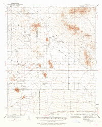
1937 Map of Shadow Mountains
USGS Topo · Published 1937About this map
Isolated homesteads and ranches define this high desert landscape on the border of Los Angeles and San Bernardino counties. In the late 1930s, this portion of the Antelope Valley was a network of dispersed family holdings such as the Vanderburg Ranch, Martin Ranch, and Brase Ranch, all connected by a regular grid of avenues and section roads. The terrain is dominated by prominent elevations including Silver Peak and Adobe Mountain, while the presence of Moody Spring and numerous wells indicates the critical importance of water access for these remote properties. A notable marker of the era's evolving transportation infrastructure is the Airway Beacon No 7, situated in the northeastern corner of the quadrangle near the Dry Lake of El Mirage.
Find a feature on this map
28 named features on this map. Tap any name to fly to it.
Don’t see what you’re looking for? This feature index may not catch every label — zoom into the map to look around manually.
Map Details
Editions of this 1937 Shadow Mountains Map
2 editions found
Other maps of this area

1901 · Southern California Sheet No. 1
USGS Topo · 1:250,000

1902 · Hesperia
USGS Topo · 1:62,500

1903 · Rock Creek
USGS Topo · 1:62,500

1903 · San Antonio
USGS Topo · 1:62,500

1904 · Southern California Sheet No. 1
USGS Topo · 1:250,000

1930 · Black Butte
USGS Topo · 1:24,000

1930 · El Mirage
USGS Topo · 1:24,000

1930 · Angle
USGS Topo · 1:24,000

1930 · Wilsona
USGS Topo · 1:24,000

1931 · Adobe
USGS Topo · 1:24,000