
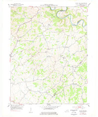
1952 Map of Shady Nook
USGS Topo · Published 1954About this map
The Licking River winds through the northern portion of this landscape, forming a natural boundary shared by Harrison and Robertson Counties. The terrain is defined by a dense network of creek valleys and ridges, where small agricultural communities like Shady Nook and Morning Glory took root in the early 1950s. This survey records a highly localized social geography, centered on country churches such as Oddville Ch and Republican Ch, and numerous family-named landmarks.
Find a feature on this map
28 named features on this map. Tap any name to fly to it.
Don’t see what you’re looking for? This feature index may not catch every label — zoom into the map to look around manually.
Map Details
Editions of this 1952 Shady Nook Map
2 editions found
Other maps of this area

1929 · Cynthiana
USGS Topo · 1:48,000

1930 · Falmouth
USGS Topo · 1:48,000

1934 · Cynthiana
USGS Topo · 1:62,500

1936 · Falmouth
USGS Topo · 1:62,500

1952 · Mount Olivet
USGS Topo · 1:24,000

1952 · Piqua
USGS Topo · 1:24,000

1952 · Claysville
USGS Topo · 1:24,000

1953 · Carlisle
USGS Topo · 1:24,000

1953 · Millersburg
USGS Topo · 1:24,000

1953 · Kelat
USGS Topo · 1:24,000