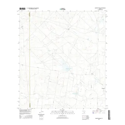
2016 Map of Shaeffer Ranch
USGS Topo · Published 2016About this map
Shaeffer Ranch anchors this South Texas landscape along the Duval and Jim Wells county line. The terrain is defined by a dense network of intermittent drainages and ranching infrastructure, where water management is central to the land's utility. Features like Romera Tank, Javalina Tank, and Mule Tank are scattered across the quadrangle, serving as vital collection points for the seasonal flows of Agua Dulce Cr and Amargosa Cr.
Find a feature on this map
29 named features on this map. Tap any name to fly to it.
Don’t see what you’re looking for? This feature index may not catch every label — zoom into the map to look around manually.
Map Details
Editions of this 2016 Shaeffer Ranch Map
This is the sole edition of this map. No revisions or reprints were ever made.
Other maps of this area

1920 · Mikeska
USGS Topo · 1:125,000

1920 · San Diego
USGS Topo · 1:62,500

1953 · Crystal City
USGS Topo · 1:250,000

1955 · Crystal City
USGS Topo · 1:250,000

1956 · Rosita Ranch
USGS Topo · 1:62,500

1956 · Laredo
USGS Topo · 1:250,000

1961 · Crystal City
USGS Topo · 1:250,000
1963 · Anna Rose
USGS Topo · 1:24,000

1963 · San Diego NE
USGS Topo · 1:24,000

1963 · San Diego
USGS Topo · 1:24,000