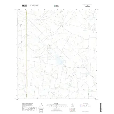
2019 Map of Shaeffer Ranch
USGS Topo · Published 2019About this map
Shaeffer Ranch serves as a central landmark in this South Texas landscape where Jim Wells and Duval counties meet. The terrain is defined by a complex network of ephemeral drainage systems and livestock watering tanks essential to ranching operations. Notable watercourses including Chiltipin Cr, Amargosa Cr, and Jarita Cr wind through the acreage, punctuated by named catchments like Mule Tank and Salado Tank. This 2019 survey documents the local infrastructure of the region, anchored by rural routes such as Co RD 172 and Nighthawk Trl. Cultural and genealogical sites are preserved in the form of the San Jose Cem in the northwest and Villareal Cem to the east, providing fixed points of heritage amidst the expansive brush country.
Find a feature on this map
25 named features on this map. Tap any name to fly to it.
Don’t see what you’re looking for? This feature index may not catch every label — zoom into the map to look around manually.
Map Details
Editions of this 2019 Shaeffer Ranch Map
This is the sole edition of this map. No revisions or reprints were ever made.
Other maps of this area

1920 · Mikeska
USGS Topo · 1:125,000

1920 · San Diego
USGS Topo · 1:62,500

1953 · Crystal City
USGS Topo · 1:250,000

1955 · Crystal City
USGS Topo · 1:250,000

1956 · Rosita Ranch
USGS Topo · 1:62,500

1956 · Laredo
USGS Topo · 1:250,000

1961 · Crystal City
USGS Topo · 1:250,000
1963 · Anna Rose
USGS Topo · 1:24,000

1963 · San Diego NE
USGS Topo · 1:24,000

1963 · San Diego
USGS Topo · 1:24,000