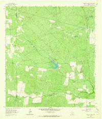
1963 Map of Shaeffer Ranch
USGS Topo · Published 1964About this map
The boundary between Duval Co and Jim Wells Co divides this South Texas ranchland during the early 1960s. The landscape is defined by an extensive network of water management features essential for cattle operations, including numerous named tanks like Mule Tank, Las Pilas Tank, and Salado Tank. The small settlement of Mendieta serves as a local hub near the San Jose Cem, while the namesake Shaeffer Ranch is positioned centrally among the brush-covered hills. A system of pipelines and a Pumping Station indicate the region's energy infrastructure, alongside traditional water-drawing sites such as the Bianca Windmill and Yellowtop Windmill. The drainage patterns of Agua Dulce Creek and Amargosa Creek are interrupted by modern engineering at Chittipin Dam No 1, illustrating the shift toward more permanent water storage in this arid environment.
Find a feature on this map
28 named features on this map. Tap any name to fly to it.
Don’t see what you’re looking for? This feature index may not catch every label — zoom into the map to look around manually.
Map Details
Editions of this 1963 Shaeffer Ranch Map
2 editions found
Other maps of this area

1920 · Mikeska
USGS Topo · 1:125,000

1920 · San Diego
USGS Topo · 1:62,500

1953 · Crystal City
USGS Topo · 1:250,000

1955 · Crystal City
USGS Topo · 1:250,000

1956 · Rosita Ranch
USGS Topo · 1:62,500

1956 · Laredo
USGS Topo · 1:250,000

1961 · Crystal City
USGS Topo · 1:250,000
1963 · Anna Rose
USGS Topo · 1:24,000

1963 · San Diego NE
USGS Topo · 1:24,000

1963 · San Diego
USGS Topo · 1:24,000