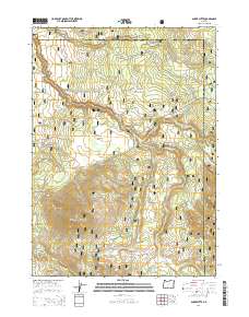
2014 Map of Shake Butte
USGS Topo · Published 2014About this map
Shake Butte rises as a prominent landmark within the Fremont National Forest, anchoring a landscape defined by its complex drainage network and high-elevation flats. This Klamath and Lake County border region is primarily shaped by the Sycan River and its numerous tributaries, including Long Creek and Paradise Creek. The presence of several permanent water sources, such as Driscol Spring, Indian Spring, and Watson Spring, underscores the importance of reliable water in this forested environment. Open areas like Squaw Flat and Crazyman Flat provide contrast to the timbered ridges, while a network of Forest Service development roads, such as Nat For Dev Rd 2823, provides access through the backcountry for forest management and recreation.
Find a feature on this map
33 named features on this map. Tap any name to fly to it.
Don’t see what you’re looking for? This feature index may not catch every label — zoom into the map to look around manually.
Map Details
Editions of this 2014 Shake Butte Map
This is the sole edition of this map. No revisions or reprints were ever made.
Other maps of this area

1889 · Klamath
USGS Topo · 1:250,000

1894 · Klamath
USGS Topo · 1:250,000

1955 · Klamath Falls
USGS Topo · 1:250,000

1958 · Klamath Falls
USGS Topo · 1:250,000

1960 · Riverbed Butte
USGS Topo · 1:62,500

1960 · Sycan Marsh
USGS Topo · 1:62,500

1966 · Shake Butte
USGS Topo · 1:24,000

1966 · Sandhill Crossing
USGS Topo · 1:24,000

1966 · Harvey Creek
USGS Topo · 1:24,000

1966 · Fremont Point
USGS Topo · 1:24,000