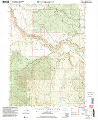
2004 Map of Shake Butte
USGS Topo · Published 2007About this map
The Sycan River carves a central path through this section of the Fremont National Forest, marking a landscape defined by significant water resources and historical transition points. A notable historic location is the Emigrant Crossing (Site), indicating a point where early travelers navigated the river's course. The terrain shifts from the high prominence of Shake Butte in the southwest to the broad, level expanses of Squaw Flat and Crazyman Flat, which suggest the high-altitude meadow and plateau geography of the Oregon interior.
Find a feature on this map
25 named features on this map. Tap any name to fly to it.
Don’t see what you’re looking for? This feature index may not catch every label — zoom into the map to look around manually.
Map Details
Editions of this 2004 Shake Butte Map
This is the sole edition of this map. No revisions or reprints were ever made.
Other maps of this area

1889 · Klamath
USGS Topo · 1:250,000

1894 · Klamath
USGS Topo · 1:250,000

1955 · Klamath Falls
USGS Topo · 1:250,000

1958 · Klamath Falls
USGS Topo · 1:250,000

1960 · Riverbed Butte
USGS Topo · 1:62,500

1960 · Sycan Marsh
USGS Topo · 1:62,500

1966 · Shake Butte
USGS Topo · 1:24,000

1966 · Sandhill Crossing
USGS Topo · 1:24,000

1966 · Harvey Creek
USGS Topo · 1:24,000

1966 · Fremont Point
USGS Topo · 1:24,000