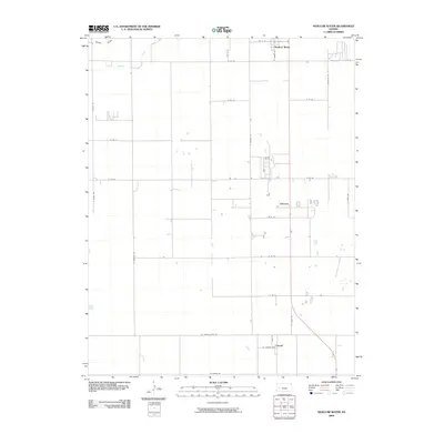
2009 Map of Shallow Water
USGS Topo · Published 2009About this map
Shallow Water serves as a primary hub within this high plains agricultural landscape of western Kansas. The survey reveals a meticulously planned grid of rural transit, where family-named and directional roads like Grant Rd and S Lariat Rd define the property boundaries and transport routes of the early 21st century. The terrain is marked by seasonal and ephemeral water features, including the notable White Woman and Rocky Draw, which highlight the drainage patterns of this semi-arid region. In the southern portion of the quadrangle, the small settlement of Friend sits at a crossroads of county-spanning routes such as W Finney Scott Rd, while Chevron marks a distinct point along the central corridor. This landscape reflects the enduring influence of the Public Land Survey System on Kansas settlement patterns, emphasizing the deep connection between the rural road network and the area's agricultural identity.
Find a feature on this map
29 named features on this map. Tap any name to fly to it.
Don’t see what you’re looking for? This feature index may not catch every label — zoom into the map to look around manually.
Map Details
Editions of this 2009 Shallow Water Map
This is the sole edition of this map. No revisions or reprints were ever made.
Other maps of this area

1940 · Scott City
USGS Topo · 1:62,500

1941 · Modoc
USGS Topo · 1:62,500

1944 · Tennis
USGS Topo · 1:62,500

1951 · Scott City
USGS Topo · 1:62,500

1951 · Modoc
USGS Topo · 1:62,500

1955 · Scott City
USGS Topo · 1:250,000

1958 · Scott City
USGS Topo · 1:250,000

1965 · Wolf NE
USGS Topo · 1:24,000
1976 · Modoc SE
USGS Topo · 1:24,000
1976 · Shallow Water
USGS Topo · 1:24,000