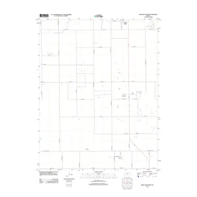
2012 Map of Shallow Water
USGS Topo · Published 2012About this map
Shallow Water serves as the primary settlement on this agricultural landscape in Scott County, positioned at the intersection of several local routes such as W Road 70 and S Lovers Ln. The terrain is characterized by a high-plains grid of section lines and gravel roads, including the long-running S Herford Rd and S Kansas Rd. Significant for local genealogy, the Prairie View Cem stands alone in the southern section of the quadrangle, north of W Finney Scott Rd. The intermittent course of White Woman Cr crosses the northwest corner, providing the only major natural drainage feature in an area otherwise defined by human engineering. Scattered settlements like Chevron and Friend reflect the late 20th-century rural infrastructure, while the density of named roads indicates the organized partition of this prairie region for grain production.
Find a feature on this map
38 named features on this map. Tap any name to fly to it.
Don’t see what you’re looking for? This feature index may not catch every label — zoom into the map to look around manually.
Map Details
Editions of this 2012 Shallow Water Map
This is the sole edition of this map. No revisions or reprints were ever made.
Other maps of this area

1940 · Scott City
USGS Topo · 1:62,500

1941 · Modoc
USGS Topo · 1:62,500

1944 · Tennis
USGS Topo · 1:62,500

1951 · Scott City
USGS Topo · 1:62,500

1951 · Modoc
USGS Topo · 1:62,500

1955 · Scott City
USGS Topo · 1:250,000

1958 · Scott City
USGS Topo · 1:250,000

1965 · Wolf NE
USGS Topo · 1:24,000
1976 · Modoc SE
USGS Topo · 1:24,000
1976 · Shallow Water
USGS Topo · 1:24,000