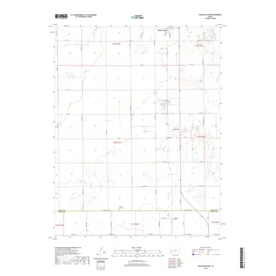
2018 Map of Shallow Water
USGS Topo · Published 2018About this map
Shallow Water and the surrounding agricultural lands of western Kansas are defined by a rhythmic grid of rural roads and scattered irrigation features. This landscape, straddling the boundary between Scott Co and Finney Co, centers on the small communities along the north-south transport corridor. The ephemeral drainage of White Woman Cr cuts across the northern townships, a natural landmark in an area otherwise shaped by human geometry. Genealogy researchers can locate the Prairie View Cem situated near the county line, while the small settlements of Chevron and Friend anchor the southern portion of the sheet. The map reveals the intense land division of the high plains, where named local routes like S Lovers Ln and Big Lowe Rd serve isolated farmsteads and the region's essential water management infrastructure.
Find a feature on this map
46 named features on this map. Tap any name to fly to it.
Don’t see what you’re looking for? This feature index may not catch every label — zoom into the map to look around manually.
Map Details
Editions of this 2018 Shallow Water Map
This is the sole edition of this map. No revisions or reprints were ever made.
Other maps of this area

1940 · Scott City
USGS Topo · 1:62,500

1941 · Modoc
USGS Topo · 1:62,500

1944 · Tennis
USGS Topo · 1:62,500

1951 · Scott City
USGS Topo · 1:62,500

1951 · Modoc
USGS Topo · 1:62,500

1955 · Scott City
USGS Topo · 1:250,000

1958 · Scott City
USGS Topo · 1:250,000

1965 · Wolf NE
USGS Topo · 1:24,000
1976 · Modoc SE
USGS Topo · 1:24,000
1976 · Shallow Water
USGS Topo · 1:24,000