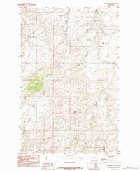
1984 Map of Shambo NE
USGS Topo · Published 1984About this map
The high-plains landscape along the border of Hill and Blaine counties is defined by a network of drainage channels and prominent elevations. Squaw Butte rises as a central landmark in this territory, overlooking the divergent paths of Bullhook Creek to the west and Boxelder Creek to the east. These waterways, including Little Boxelder Creek, suggest a landscape shaped by seasonal runoff and cattle ranching, where water sources dictated the movement of early homesteaders and livestock in this portion of north-central Montana. Sparse ranch roads and trails navigate between deep coulees like Staten Coulee and Spring Coulee, illustrating the difficulty of traversing this broken terrain in the mid-1980s. This survey, based on field work updated through 1984, preserves the specific ranching infrastructure and topographic details of the Montana grasslands before modern changes.
Find a feature on this map
7 named features on this map. Tap any name to fly to it.
Don’t see what you’re looking for? This feature index may not catch every label — zoom into the map to look around manually.
Map Details
Editions of this 1984 Shambo NE Map
This is the sole edition of this map. No revisions or reprints were ever made.
Other maps of this area

1904 · Yantic
USGS Topo · 1:62,500

1904 · Havre
USGS Topo · 1:62,500

1912 · Zurich
USGS Topo · 1:125,000

1912 · Thibedeau Lake
USGS Topo · 1:125,000

1953 · Havre
USGS Topo · 1:250,000

1956 · Lloyd
USGS Topo · 1:62,500

1957 · Havre
USGS Topo · 1:250,000

1958 · Havre
USGS Topo · 1:250,000

1959 · Shambo
USGS Topo · 1:62,500

1964 · Havre SE
USGS Topo · 1:24,000