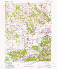
1965 Map of Shandon
USGS Topo · Published 1976About this map
The U S Reservation (Atomic Energy Commission) dominates the central landscape of this mid-1960s survey, marking a period of significant industrial and federal activity near Fernald. This facility is surrounded by the established agricultural and residential communities of Shandon, Ross, and New Haven. The area's transit and logistics are defined by the Chesapeake and Ohio railroad corridor and the winding course of the Great Miami River, which is flanked by numerous Gravel Pits indicating active resource extraction.
Find a feature on this map
46 named features on this map. Tap any name to fly to it.
Don’t see what you’re looking for? This feature index may not catch every label — zoom into the map to look around manually.
Map Details
Editions of this 1965 Shandon Map
3 editions found
Other maps of this area

1914 · West Cincinnati
USGS Topo · 1:62,500

1915 · Lawrenceburg
USGS Topo · 1:48,000

1915 · Harrison
USGS Topo · 1:48,000

1915 · Hamilton
USGS Topo · 1:62,500

1917 · Hamilton
USGS Topo · 1:62,500

1928 · Lawrenceburg
USGS Topo · 1:62,500

1932 · Lawrenceburg
USGS Topo · 1:62,500

1943 · Hooven
USGS Topo · 1:24,000

1953 · Cincinnati West
USGS Topo · 1:24,000

1953 · Cincinnati
USGS Topo · 1:250,000