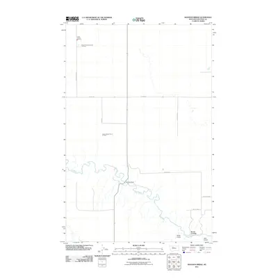
2011 Map of Shannon Bridge
USGS Topo · Published 2011About this map
The Teton River meanders through this portion of Chouteau County, creating a complex series of oxbows and bends that define the local geography. This rural landscape is anchored by small, community-centered locations such as Shannon Bridge and Woods Crossing, where local roads converge at the river's edge. The presence of the German Baptist Church Cemetery and the Knees Community Church Cemetery highlights the deep-rooted settlement patterns and genealogical significance of this Montana prairie region. Public safety and infrastructure are represented by the Knees Vol Fire Company, situated along the northern section of Knees Church Rd. The terrain is further marked by several distinctive drainages, including Sheep Coulee and Wolf Coulee, which cut through the open country toward the river valley.
Find a feature on this map
17 named features on this map. Tap any name to fly to it.
Don’t see what you’re looking for? This feature index may not catch every label — zoom into the map to look around manually.
Map Details
Editions of this 2011 Shannon Bridge Map
This is the sole edition of this map. No revisions or reprints were ever made.
Other maps of this area

1886 · Great Falls
USGS Topo · 1:250,000

1949 · Timber Coulee
USGS Topo · 1:62,500

1950 · Timber Coulee
USGS Topo · 1:62,500

1950 · Dent Bridge
USGS Topo · 1:62,500

1954 · Great Falls
USGS Topo · 1:250,000

1954 · Shelby
USGS Topo · 1:250,000

1957 · Great Falls
USGS Topo · 1:250,000

1958 · Shelby
USGS Topo · 1:250,000
1965 · Sheep Coulee Spring
USGS Topo · 1:24,000

1970 · Knees
USGS Topo · 1:24,000