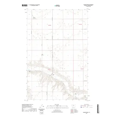
2020 Map of Shannon Bridge
USGS Topo · Published 2020About this map
Teton River carves a deep valley through this Chouteau County landscape, creating a dramatic geographic divide bridged only at Shannon Bridge. The surrounding plains are defined by an orderly grid of section lines and gravel routes, including the evocatively named Bootlegger Trl and Woods Xing N. This area maintains a strong connection to its pioneer-era roots, evidenced by the presence of the Knees Community Church Cem and the German Baptist Church Cem, which serve as vital landmarks for local genealogical research.
Find a feature on this map
20 named features on this map. Tap any name to fly to it.
Don’t see what you’re looking for? This feature index may not catch every label — zoom into the map to look around manually.
Map Details
Editions of this 2020 Shannon Bridge Map
This is the sole edition of this map. No revisions or reprints were ever made.
Other maps of this area

1886 · Great Falls
USGS Topo · 1:250,000

1949 · Timber Coulee
USGS Topo · 1:62,500

1950 · Timber Coulee
USGS Topo · 1:62,500

1950 · Dent Bridge
USGS Topo · 1:62,500

1954 · Great Falls
USGS Topo · 1:250,000

1954 · Shelby
USGS Topo · 1:250,000

1957 · Great Falls
USGS Topo · 1:250,000

1958 · Shelby
USGS Topo · 1:250,000
1965 · Sheep Coulee Spring
USGS Topo · 1:24,000

1970 · Knees
USGS Topo · 1:24,000