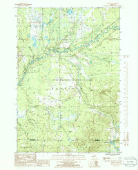
1985 Map of Sharon
USGS Topo · Published 1986About this map
The Manistee River winds through the heart of this mid-1980s landscape, serving as a focal point for the recreational and industrial character of Kalkaska County. Much of the terrain is dominated by the Pere Marquette State Forest, where the river's path is joined by tributaries like Willow Creek and Pierson Creek. A distinct industrial presence is noted in the southern portion of the quadrangle with the Cannon Creek Gas Field, while a Gravel Pit further indicates local resource extraction. Evidence of earlier transportation networks persists via the Old RR Grade cutting through the forest, suggesting the area's history of logging and rail transit. Significant wetlands including O'Neil Swamp and Devil Creek Swamp illustrate the low-lying, water-rich environment that defines the boundary between Orange and Garfield townships.
Find a feature on this map
29 named features on this map. Tap any name to fly to it.
Don’t see what you’re looking for? This feature index may not catch every label — zoom into the map to look around manually.
Map Details
Editions of this 1985 Sharon Map
This is the sole edition of this map. No revisions or reprints were ever made.
Other maps of this area

1949 · Black Creek
USGS Topo · 1:24,000

1949 · Fletcher
USGS Topo · 1:62,500

1950 · Fletcher
USGS Topo · 1:24,000

1954 · Traverse City
USGS Topo · 1:250,000

1956 · Kalkaska
USGS Topo · 1:62,500

1956 · Houghton Lake
USGS Topo · 1:62,500

1956 · Lake City
USGS Topo · 1:62,500

1958 · Traverse City
USGS Topo · 1:250,000

1983 · Cadillac
USGS Topo · 1:100,000

1983 · Stittsville
USGS Topo · 1:24,000