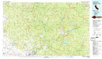
1980 Map of Shaver Lake
USGS Topo · Published 1991About this map
Sierra National Forest dominates the landscape of this 1980 survey, where the Western Sierra Nevada meets the foothills of the San Joaquin Valley. The map documents a critical region of hydroelectric and recreational development, centered around Shaver Lake, Huntington Lake, and Bass Lake. These water bodies, along with the Mammoth Pool Reservoir on the South Fork San Joaquin River, represent the sophisticated water management systems developed to serve Central California.
Find a feature on this map
137 named features on this map. Tap any name to fly to it.
Don’t see what you’re looking for? This feature index may not catch every label — zoom into the map to look around manually.
Map Details
Editions of this 1980 Shaver Lake Map
3 editions found

Other maps of this area

1893 · Sonora
USGS Topo · 1:125,000

1896 · Sonora
USGS Topo · 1:125,000

1897 · Sonora
USGS Topo · 1:125,000

1897 · Yosemite
USGS Topo · 1:125,000

1898 · Sonora
USGS Topo · 1:125,000

1900 · Yosemite
USGS Topo · 1:125,000

1901 · Mt. Lyell
USGS Topo · 1:125,000

1903 · Yosemite
USGS Topo · 1:125,000

1903 · Tehipite
USGS Topo · 1:125,000

1904 · Kaiser
USGS Topo · 1:125,000