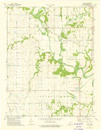
1973 Map of Shaw
USGS Topo · Published 1975About this map
The Neosho River meanders across this rural Kansas landscape, defining the agricultural and industrial character of the region in the early 1970s. The small settlements of Shaw and Urbana serve as local anchors, while the Atchison Topeka and Santa Fe railroad cuts across the terrain, illustrating the vital transportation links that supported the local economy. Evidence of the area's resource extraction is visible through scattered Oil Wells and a Quarry, highlighting the intersection of farming and industry.
Find a feature on this map
23 named features on this map. Tap any name to fly to it.
Don’t see what you’re looking for? This feature index may not catch every label — zoom into the map to look around manually.
Map Details
Editions of this 1973 Shaw Map
This is the sole edition of this map. No revisions or reprints were ever made.
Other maps of this area

1886 · Iola
USGS Topo · 1:125,000

1886 · Parsons
USGS Topo · 1:125,000

1893 · Iola
USGS Topo · 1:125,000

1893 · Parsons
USGS Topo · 1:125,000

1904 · Iola
USGS Topo · 1:125,000

1943 · McCune
USGS Topo · 1:62,500

1945 · Mc Cune
USGS Topo · 1:62,500

1945 · Parsons
USGS Topo · 1:62,500

1946 · Parsons
USGS Topo · 1:62,500

1947 · Parsons
USGS Topo · 1:62,500