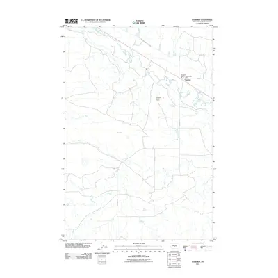
2011 Map of Shawmut
USGS Topo · Published 2011About this map
Shawmut sits at the heart of this Wheatland County landscape, where the winding course of the Musselshell River dictates the shape of the local agriculture and infrastructure. As a small settlement in central Montana, the community relies on the essential services of the Shawmut Post Office and the Wheatland Co Fire Dept. The map illustrates a highly managed water system designed to support ranching and farming in a semi-arid environment, notably featuring the Deadmans Basin Supply Canal and local water control structures like Berg Dam and Cinnamon Number 6 Dam. The grid of rural roads, including S Shawmut Rd, connects scattered homesteads to the river valley, reflecting the enduring spatial patterns of Big Sky country at the beginning of the twenty-first century.
Find a feature on this map
11 named features on this map. Tap any name to fly to it.
Don’t see what you’re looking for? This feature index may not catch every label — zoom into the map to look around manually.
Map Details
Editions of this 2011 Shawmut Map
This is the sole edition of this map. No revisions or reprints were ever made.
Other maps of this area

1889 · Big Snowy Mountain
USGS Topo · 1:250,000

1893 · Big Snowy Mountain
USGS Topo · 1:250,000

1954 · Roundup
USGS Topo · 1:250,000

1958 · Roundup
USGS Topo · 1:250,000

1985 · Jim Creek
USGS Topo · 1:24,000

1985 · Progress
USGS Topo · 1:24,000
1985 · O'Brien Hill
USGS Topo · 1:24,000

1986 · Shawmut
USGS Topo · 1:24,000

1986 · Halbert Creek South
USGS Topo · 1:24,000
1986 · Deadmans Basin Reservoir
USGS Topo · 1:24,000