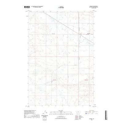
2020 Map of Shawmut
USGS Topo · Published 2020About this map
Shawmut serves as the focal point of this Central Montana landscape, situated where the high plains meet the intricate riparian corridor of the Musselshell River. The map highlights a rural infrastructure defined by water management and transit, most notably the Deadmans Basin Supply Canal which cuts across the northern territory toward the townsite. The local road network, including Hedgesville Rd and Shawmut Rd, follows the section lines of the Public Land Survey System, illustrating the orderly grid of T7N and T6N that governs this agricultural region. The winding course of the river creates a sharp contrast with the surrounding dry coulees and benchlands, indicating the vital importance of the Musselshell for irrigation and settlement in Wheatland County. This modern survey provides a clear view of how topographic features and man-made waterways like Canal Rd continue to shape the community's layout and land use.
Find a feature on this map
12 named features on this map. Tap any name to fly to it.
Don’t see what you’re looking for? This feature index may not catch every label — zoom into the map to look around manually.
Map Details
Editions of this 2020 Shawmut Map
This is the sole edition of this map. No revisions or reprints were ever made.
Other maps of this area

1889 · Big Snowy Mountain
USGS Topo · 1:250,000

1893 · Big Snowy Mountain
USGS Topo · 1:250,000

1954 · Roundup
USGS Topo · 1:250,000

1958 · Roundup
USGS Topo · 1:250,000

1985 · Jim Creek
USGS Topo · 1:24,000

1985 · Progress
USGS Topo · 1:24,000
1985 · O'Brien Hill
USGS Topo · 1:24,000

1986 · Shawmut
USGS Topo · 1:24,000

1986 · Halbert Creek South
USGS Topo · 1:24,000
1986 · Deadmans Basin Reservoir
USGS Topo · 1:24,000