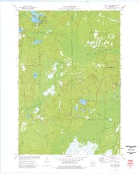
1973 Map of Shay Lake
USGS Topo · Published 1977About this map
Nicolet National Forest dominates this northern Wisconsin landscape, characterized by a complex network of glacial lakes and wetlands during the early 1970s. The area around Shay Lake and Gilkey Lake shows a established pattern of seasonal and rural settlement, with St Marys of the Lake Ch serving the local community near the northern water bodies. A small sandpit and a remote landing strip north of Turtle Lake suggest a mix of local resource extraction and essential aviation access for this heavily forested region.
Find a feature on this map
36 named features on this map. Tap any name to fly to it.
Don’t see what you’re looking for? This feature index may not catch every label — zoom into the map to look around manually.
Map Details
Editions of this 1973 Shay Lake Map
This is the sole edition of this map. No revisions or reprints were ever made.
Other maps of this area

1940 · Thunder Mtn.
USGS Topo · 1:48,000

1940 · Athelstane
USGS Topo · 1:48,000

1941 · Coleman
USGS Topo · 1:48,000

1942 · Athelstane
USGS Topo · 1:48,000

1942 · Coleman
USGS Topo · 1:48,000

1942 · Breed
USGS Topo · 1:48,000

1950 · Coleman
USGS Topo · 1:48,000

1951 · Thunder Mountain
USGS Topo · 1:48,000

1952 · Mountain
USGS Topo · 1:48,000

1954 · Iron Mountain
USGS Topo · 1:250,000