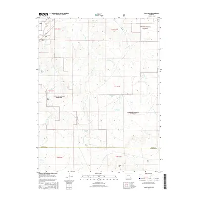
2016 Map of Sheep Canyon
USGS Topo · Published 2016About this map
The Comanche National Grassland dominates this section of the High Plains, where the boundary between Otero and Las Animas counties cuts through a landscape of deep canyons and seasonal drainages. The area's complex hydrology is defined by the Sheep Canyon Arroyo and the winding path of the Hoe Ranch Arroyo, alongside several cattle-country water sources such as Government Pond, Smith Pond, and Rourke Reservoir. Topographical landmarks like Iron Springs Hills, Jack Point, and Cedar Hill rise above the drainage basins. The presence of the Crooked Arroyo CA-1 Detention Reservoir highlights modern water management efforts in this arid ranching environment, while rugged features like Sheep Canyon and Bent Canyon provide a glimpse into the traditional open-range character of Southeast Colorado.
Find a feature on this map
27 named features on this map. Tap any name to fly to it.
Don’t see what you’re looking for? This feature index may not catch every label — zoom into the map to look around manually.
Map Details
Editions of this 2016 Sheep Canyon Map
This is the sole edition of this map. No revisions or reprints were ever made.
Other maps of this area

1891 · Timpas
USGS Topo · 1:125,000

1894 · Timpas
USGS Topo · 1:125,000

1955 · La Junta
USGS Topo · 1:250,000

1958 · La Junta
USGS Topo · 1:250,000

1965 · La Junta SW
USGS Topo · 1:24,000

1968 · La Junta
USGS Topo · 1:250,000

1972 · Packers Gap
USGS Topo · 1:24,000
1972 · Stage Canyon
USGS Topo · 1:24,000
1972 · Timpas SW
USGS Topo · 1:24,000
1972 · Lockwood Arroyo
USGS Topo · 1:24,000