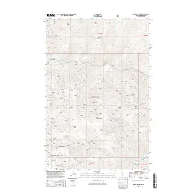
2013 Map of Sheep Mountain
USGS Topo · Published 2013About this map
The North Fork Clearwater River winds through the heart of the Clearwater National Forest in this 2013 Idaho survey. This wilderness landscape is defined by the high peaks of the Sheep Mountain Range, including the prominent Sheep Mtn and Eagle Point. The drainage patterns are clearly marked by numerous tributaries such as Little Washington Cr, Sheep Cr, and Isabella Cr feeding into the main river channel. For those navigating the backcountry, the map identifies essential terrain crossings like Swanson Saddle and Sheep Mountain Saddle. The northern reaches are characterized by steep ridges like Fern Ridge and high overlooks such as Preceptor Point. Recreational access is centered on the Aquarius Campground along the river, while a network of forest roads including Co RD 247 and Co RD 681 provide the primary routes through this mountainous terrain.
Find a feature on this map
45 named features on this map. Tap any name to fly to it.
Don’t see what you’re looking for? This feature index may not catch every label — zoom into the map to look around manually.
Map Details
Editions of this 2013 Sheep Mountain Map
This is the sole edition of this map. No revisions or reprints were ever made.
Other maps of this area

1911 · Lolo
USGS Topo · 1:250,000

1913 · Lolo
USGS Topo · 1:250,000

1923 · Washington Creek
USGS Topo · 1:125,000

1956 · Hamilton
USGS Topo · 1:250,000

1959 · Hamilton
USGS Topo · 1:250,000

1960 · Hamilton
USGS Topo · 1:250,000
1963 · Mallard Peak
USGS Topo · 1:24,000

1963 · Sheep Mtn
USGS Topo · 1:24,000
1963 · Buzzard Roost
USGS Topo · 1:24,000
1963 · Pole Mtn
USGS Topo · 1:24,000