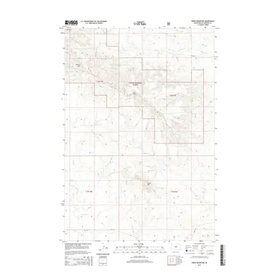
2015 Map of Sheep Mountain
USGS Topo · Published 2015About this map
Slim Buttes rise above the high plains of Harding County within the Custer National Forest, creating a landscape defined by significant elevation changes and seasonal water sources. The terrain is marked by prominent landforms such as Sheep Mtn and Willard Gap, with the northern reaches drained by Antelope Creek and its associated breaks. Numerous named springs, including Moonshine Spring, Batt Spring, and Fuller Spring, indicate the vital role of water points in this arid region of South Dakota. Human impact is sparse, primarily seen in the section-line roads like Marty Rd and the scattered drainages of Coal Gulch and Dry Creek. The map documents a rugged corner of the state where ranching and natural resource management intersect with the protected forest lands of the Great Plains.
Find a feature on this map
25 named features on this map. Tap any name to fly to it.
Don’t see what you’re looking for? This feature index may not catch every label — zoom into the map to look around manually.
Map Details
Editions of this 2015 Sheep Mountain Map
This is the sole edition of this map. No revisions or reprints were ever made.
Other maps of this area

1935 · Hoover
USGS Topo · 1:125,000

1954 · Lemmon
USGS Topo · 1:250,000

1957 · Lemmon
USGS Topo · 1:250,000

1968 · Irish Butte
USGS Topo · 1:24,000

1968 · J B Hill
USGS Topo · 1:24,000

1968 · Sheep Mountain
USGS Topo · 1:24,000

1968 · Flat Top Butte
USGS Topo · 1:24,000
1978 · Porter Creek
USGS Topo · 1:24,000
1978 · Fish Draw
USGS Topo · 1:24,000

1980 · Redig
USGS Topo · 1:100,000