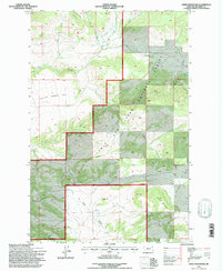
1995 Map of Sheep Mountain
USGS Topo · Published 1997About this map
The Lewis and Clark National Forest encompasses a significant portion of this landscape, where the high-elevation terrain of Sheep Mountain and the expansive Sheep Creek Bar dominate the topography. Grounded in a 1995 revision of mid-century aerial surveys, the map reveals a network of watercourses including Cottonwood Creek and Horse Creek that drain toward the Prairie. A distinct National Forest Boundary separates the protected forest lands from the adjacent terrain, marked by the 3rd Standard Parallel North. High passes and ridges, such as Elk Horn Pass and Rocky Ridge, provide navigational anchors within the mountain range. The map illustrates a landscape primarily defined by its natural drainage patterns and topographical relief, with Bear Gulch and Jack Creek carving through the slopes of the northern sections.
Find a feature on this map
22 named features on this map. Tap any name to fly to it.
Don’t see what you’re looking for? This feature index may not catch every label — zoom into the map to look around manually.
Map Details
Editions of this 1995 Sheep Mountain Map
This is the sole edition of this map. No revisions or reprints were ever made.
Other maps of this area

1886 · Fort Logan
USGS Topo · 1:250,000

1886 · Little Belt Mts.
USGS Topo · 1:250,000

1894 · Little Belt Mts.
USGS Topo · 1:250,000

1897 · Little Belt Mts.
USGS Topo · 1:250,000

1898 · Little Belt Mts.
USGS Topo · 1:250,000

1902 · Little Belt Mts.
USGS Topo · 1:250,000

1948 · White Sulphur Springs
USGS Topo · 1:250,000

1958 · White Sulphur Springs
USGS Topo · 1:250,000

1961 · White Sulphur Springs
USGS Topo · 1:250,000

1965 · White Sulphur Springs
USGS Topo · 1:250,000