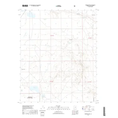
2018 Map of Sheepskin Wash
USGS Topo · Published 2018About this map
Sitgreaves National Forest anchors the southern portion of this high-desert landscape in Navajo County, where a network of seasonal drainages and water-management features defines the territory. The terrain is shaped by the prominent Pink Cliffs to the northeast and the branching systems of Phoenix Park Wash and Sheepskin Wash. In an area where permanent water is scarce, the map reveals a sophisticated system of livestock and catchment basins such as Happy Tank, Rattlesnake Tank, and Sacaton Tank. Significant landmarks like Indian Rock and various draws, including Buckhorn Draw and Bushman Draw, serve as primary navigational points across the arid flats. The presence of Dry Lake in the northwest and the solitary Indian Pottery Rd in the southeast suggests a landscape utilized for ranching and forest management, where these named tanks and washes represent the essential landmarks for local navigation and land use.
Find a feature on this map
27 named features on this map. Tap any name to fly to it.
Don’t see what you’re looking for? This feature index may not catch every label — zoom into the map to look around manually.
Map Details
Editions of this 2018 Sheepskin Wash Map
This is the sole edition of this map. No revisions or reprints were ever made.
Other maps of this area

1886 · Holbrook
USGS Topo · 1:250,000

1893 · Holbrook
USGS Topo · 1:250,000

1954 · Holbrook
USGS Topo · 1:250,000

1957 · Holbrook
USGS Topo · 1:250,000

1958 · Holbrook
USGS Topo · 1:250,000

1960 · Holbrook
USGS Topo · 1:250,000

1961 · Clay Springs
USGS Topo · 1:62,500
1970 · Cactus Flat
USGS Topo · 1:24,000
1970 · Second Knolls
USGS Topo · 1:24,000
1970 · Flattop Hill
USGS Topo · 1:24,000