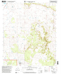
1998 Map of Sheepskin Wash
USGS Topo · Published 2000About this map
Sitgreaves National Forest covers the southern portion of this high-country landscape, where the headwaters of Phoenix Park Wash and Sheepskin Wash drain through complex terrain. The topography is defined by the prominent Pink Cliffs to the north and numerous depressions that serve as natural collection points for water. A network of livestock infrastructure characterizes the area, including the Rocking Chair Ranch and various water sources like Indian Rock Tank, Morris Tank, and Sacaton Tank. Industrial activity in the late 20th century is evidenced by the presence of a Pulp Mill and Morris Windmill, while residential development appears along Carson Drive. This map captures a specialized landscape of ranching and timber resources before further modern shifts altered the remote northern Arizona corridor.
Find a feature on this map
33 named features on this map. Tap any name to fly to it.
Don’t see what you’re looking for? This feature index may not catch every label — zoom into the map to look around manually.
Map Details
Editions of this 1998 Sheepskin Wash Map
This is the sole edition of this map. No revisions or reprints were ever made.
Other maps of this area

1886 · Holbrook
USGS Topo · 1:250,000

1893 · Holbrook
USGS Topo · 1:250,000

1954 · Holbrook
USGS Topo · 1:250,000

1957 · Holbrook
USGS Topo · 1:250,000

1958 · Holbrook
USGS Topo · 1:250,000

1960 · Holbrook
USGS Topo · 1:250,000

1961 · Clay Springs
USGS Topo · 1:62,500
1970 · Cactus Flat
USGS Topo · 1:24,000
1970 · Second Knolls
USGS Topo · 1:24,000
1970 · Flattop Hill
USGS Topo · 1:24,000