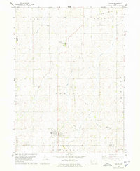
1978 Map of Shelby
USGS Topo · Published 1978About this map
Shelby anchors the southern portion of this landscape at the intersection of several township and county boundaries, including Shelby Co Pottawattamie Co. The terrain is characterized by the winding drainage systems of Silver Creek, Little Silver Creek, and Keg Creek, which carve through the agricultural uplands. A significant historical marker on the land is the Old Railroad Grade which traverses the northern sections through Cass and Lincoln townships, passing near the settlement of Tennant. This abandoned line represents the changing transportation priorities of the mid-20th century as rail networks were consolidated or removed. Further east, the small community of Corley sits near the border of Fairview, while local genealogy is rooted in sites like Olson Cem and another Cem located near the old rail corridor.
Find a feature on this map
20 named features on this map. Tap any name to fly to it.
Don’t see what you’re looking for? This feature index may not catch every label — zoom into the map to look around manually.
Map Details
Editions of this 1978 Shelby Map
This is the sole edition of this map. No revisions or reprints were ever made.
Other maps of this area

1954 · Omaha
USGS Topo · 1:250,000

1956 · Neola
USGS Topo · 1:24,000

1957 · Omaha
USGS Topo · 1:250,000

1958 · Omaha
USGS Topo · 1:250,000

1963 · Avoca NW
USGS Topo · 1:24,000

1963 · Avoca
USGS Topo · 1:24,000

1978 · Panama
USGS Topo · 1:24,000

1978 · Corley
USGS Topo · 1:24,000

1978 · Persia
USGS Topo · 1:24,000
1978 · Portsmouth
USGS Topo · 1:24,000