
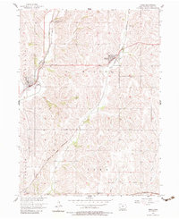
1956 Map of Neola
USGS Topo · Published 1958About this map
Neola and Minden anchor this mid-century look at Pottawattamie County, Iowa, where the landscape is defined by its dense network of major railroads. The Chicago Milwaukee St Paul and Pacific and Chicago Great Western lines converge near the valley of Mosquito Creek, illustrating the era's rail-heavy logistics before the dominance of the modern interstate system.
Find a feature on this map
22 named features on this map. Tap any name to fly to it.
Don’t see what you’re looking for? This feature index may not catch every label — zoom into the map to look around manually.
Map Details
Editions of this 1956 Neola Map
2 editions found
Other maps of this area

1954 · Omaha
USGS Topo · 1:250,000

1956 · Underwood
USGS Topo · 1:24,000

1956 · Mc Clelland
USGS Topo · 1:24,000

1957 · Omaha
USGS Topo · 1:250,000

1957 · Taylor
USGS Topo · 1:24,000

1958 · Omaha
USGS Topo · 1:250,000

1963 · Avoca NW
USGS Topo · 1:24,000

1963 · Oakland
USGS Topo · 1:24,000
1978 · Hard Scratch
USGS Topo · 1:24,000

1978 · Persia
USGS Topo · 1:24,000