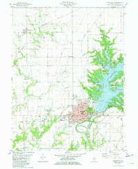
1981 Map of Shelbyville
USGS Topo · Published 1982About this map
The Kaskaskia River and the massive impoundment of Lake Shelbyville dominate this central Illinois landscape, showing the dramatic transformation of the river valley into a major recreation and water management hub. The city of Shelbyville serves as the focal point, where the Shelbyville Dam West Access Area and Shelbyville Dam East Access Area mark the engineering that reshaped the local geography. The map captures a detailed transition between the established street grid of the county seat—featuring the Courthouse, Hospital, and schools like Main St Sch and Vine St Sch—and the surrounding rural landscape defined by township boundaries such as Okaw and Rose. Numerous family and community burial grounds, including Glenwood Cem, Oliver Cem, and Smith Cem, are scattered across the uplands, offering significant data for genealogical research. Transportation patterns are clearly delineated by the Conrail lines and the Shelby County Airport, illustrating the region's 1980s infrastructure.
Find a feature on this map
51 named features on this map. Tap any name to fly to it.
Don’t see what you’re looking for? This feature index may not catch every label — zoom into the map to look around manually.
Map Details
Editions of this 1981 Shelbyville Map
2 editions found
Other maps of this area

1935 · Sullivan
USGS Topo · 1:48,000

1940 · Sullivan
USGS Topo · 1:62,500

1942 · Shelbyville
USGS Topo · 1:62,500

1946 · Shelbyville
USGS Topo · 1:62,500

1947 · Stewardson
USGS Topo · 1:62,500

1949 · Stewardson
USGS Topo · 1:62,500

1949 · Dalton City
USGS Topo · 1:62,500

1958 · Decatur
USGS Topo · 1:250,000

1961 · Decatur
USGS Topo · 1:250,000

1980 · Middlesworth
USGS Topo · 1:24,000