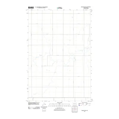
2011 Map of Sheldon NW
USGS Topo · Published 2011About this map
The Maple River meanders sharply through this rural landscape northwest of Sheldon, its winding course defining the topography of this portion of Ransom County. This 2011 survey illustrates a highly structured agricultural grid, where section lines are strictly maintained by a network of gravel and local roads like 140th Ave SE and 46th St SE. The map provides a clear look at the intersection of natural hydrology and human geometry, showing how the river's riparian curves break the rigid pattern of the surrounding fields. While the area is sparsely settled, the detailed placement of rural routes such as 147th Ave SE and 53rd St SE reveals the underlying infrastructure supporting the local farming economy at the start of the 21st century.
Find a feature on this map
16 named features on this map. Tap any name to fly to it.
Don’t see what you’re looking for? This feature index may not catch every label — zoom into the map to look around manually.
Map Details
Editions of this 2011 Sheldon NW Map
This is the sole edition of this map. No revisions or reprints were ever made.
Other maps of this area

1895 · Casselton
USGS Topo · 1:125,000

1897 · Tower
USGS Topo · 1:125,000

1897 · Casselton
USGS Topo · 1:125,000

1953 · Fargo
USGS Topo · 1:250,000

1956 · Fargo
USGS Topo · 1:250,000

1960 · Coburn
USGS Topo · 1:24,000

1960 · Enderlin South
USGS Topo · 1:24,000
1960 · Sheldon
USGS Topo · 1:24,000

1961 · Sheldon NW
USGS Topo · 1:24,000
1961 · Sheldon NE
USGS Topo · 1:24,000