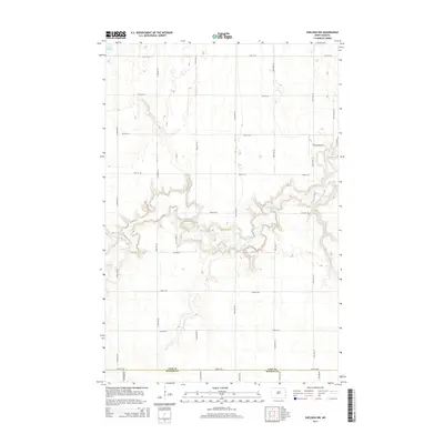
2014 Map of Sheldon NW
USGS Topo · Published 2014About this map
The Maple River carves a winding, incised path through this prairie landscape, defining the central geography of the border between Cass and Ransom counties. This 2014 survey reveals a transition from the level agricultural uplands to the complex riparian topography of the river valley. The region is marked by a precise grid of rural section roads, including 50th St SE and 143rd Ave SE, which serve the agricultural needs of Coburn Township. A notable landmark in the northeast is the J Vining Airport, located just west of the river's bends near the edge of the quadrangle. The map captures the subtle relationship between the high plains drainage and the deeply cut river channel, which forms the most significant topographical relief in an otherwise strictly surveyed rural grid.
Find a feature on this map
20 named features on this map. Tap any name to fly to it.
Don’t see what you’re looking for? This feature index may not catch every label — zoom into the map to look around manually.
Map Details
Editions of this 2014 Sheldon NW Map
This is the sole edition of this map. No revisions or reprints were ever made.
Other maps of this area

1895 · Casselton
USGS Topo · 1:125,000

1897 · Tower
USGS Topo · 1:125,000

1897 · Casselton
USGS Topo · 1:125,000

1953 · Fargo
USGS Topo · 1:250,000

1956 · Fargo
USGS Topo · 1:250,000

1960 · Coburn
USGS Topo · 1:24,000

1960 · Enderlin South
USGS Topo · 1:24,000
1960 · Sheldon
USGS Topo · 1:24,000

1961 · Sheldon NW
USGS Topo · 1:24,000
1961 · Sheldon NE
USGS Topo · 1:24,000