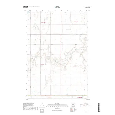
2018 Map of Sheldon NW
USGS Topo · Published 2018About this map
The Maple River meanders sharply through the southern half of this landscape, carving a deep coulee across the prairie of eastern North Dakota. Near the southern border where the Cass Co Ransom Co line divides the townships, the river valley becomes the dominant geographic feature, contrasted by the rigid section-line grid of the surrounding agricultural land. In the western portion of the map, the Highland Township Pioneer Cem sits as a quiet landmark for genealogical research, located just north of 51st St SE. The northern reaches are dotted with prairie potholes including Lake Bertha, a characteristic remnant of the region's glacial history. For those studying 21st-century rural infrastructure, the small J Vining Airport appears near the eastern edge, serving the local farming community.
Find a feature on this map
23 named features on this map. Tap any name to fly to it.
Don’t see what you’re looking for? This feature index may not catch every label — zoom into the map to look around manually.
Map Details
Editions of this 2018 Sheldon NW Map
This is the sole edition of this map. No revisions or reprints were ever made.
Other maps of this area

1895 · Casselton
USGS Topo · 1:125,000

1897 · Tower
USGS Topo · 1:125,000

1897 · Casselton
USGS Topo · 1:125,000

1953 · Fargo
USGS Topo · 1:250,000

1956 · Fargo
USGS Topo · 1:250,000

1960 · Coburn
USGS Topo · 1:24,000

1960 · Enderlin South
USGS Topo · 1:24,000
1960 · Sheldon
USGS Topo · 1:24,000

1961 · Sheldon NW
USGS Topo · 1:24,000
1961 · Sheldon NE
USGS Topo · 1:24,000