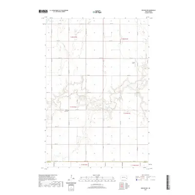
2020 Map of Sheldon NW
USGS Topo · Published 2020About this map
The Maple River meanders through the central and southern sections of this landscape, its winding course defining the local topography as it flows through Coburn Township. On the western bank, the Highland Township Pioneer Cem serves as a significant marker of early settlement history in this rural corner of North Dakota. The terrain is characterized by the agricultural grid of the Public Land Survey System, with numerous sections designated within the Ransom and Cass County borderlands. Small bodies of water like Lake Bertha dot the northern reaches, while the presence of the J Vining Airport near the eastern boundary indicates the integration of local aviation into the rural economy. This 2020 edition provides a clear view of the established road network, including Co Rd 16 and Co Rd 7, which facilitate travel across these prairie townships.
Find a feature on this map
30 named features on this map. Tap any name to fly to it.
Don’t see what you’re looking for? This feature index may not catch every label — zoom into the map to look around manually.
Map Details
Editions of this 2020 Sheldon NW Map
This is the sole edition of this map. No revisions or reprints were ever made.
Other maps of this area

1895 · Casselton
USGS Topo · 1:125,000

1897 · Tower
USGS Topo · 1:125,000

1897 · Casselton
USGS Topo · 1:125,000

1953 · Fargo
USGS Topo · 1:250,000

1956 · Fargo
USGS Topo · 1:250,000

1960 · Coburn
USGS Topo · 1:24,000

1960 · Enderlin South
USGS Topo · 1:24,000
1960 · Sheldon
USGS Topo · 1:24,000

1961 · Sheldon NW
USGS Topo · 1:24,000
1961 · Sheldon NE
USGS Topo · 1:24,000