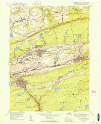
1950 Map of Shenandoah
USGS Topo · Published 1950About this map
Shenandoah and Mahanoy City anchor this portrait of the Pennsylvania anthracite region, showcasing an intricate network of industrial rail lines and mountain-top reservoirs. The landscape is dominated by the ridges of Locust Mountain and Bear Ridge, where the complex rail systems of the Reading, Lehigh Valley, and Pennsylvania lines converge to serve local collieries. Cultural landmarks like The Peddlars Grave and the Old White Ch appear alongside company towns such as Saint Nicholas and Maizeville. The prevalence of numbered water sources, including the Kehly Run Reservoirs and Raven Run Reservoirs, underscores the massive engineering required to sustain both the mining operations and the dense populations of Frackville and Gilberton during the post-war industrial era.
Find a feature on this map
85 named features on this map. Tap any name to fly to it.
Don’t see what you’re looking for? This feature index may not catch every label — zoom into the map to look around manually.
Map Details
Editions of this 1950 Shenandoah Map
2 editions found
Other maps of this area

1889 · Catawissa
USGS Topo · 1:62,500

1889 · Pottsville
USGS Topo · 1:62,500

1891 · Pottsville
USGS Topo · 1:62,500

1892 · Catawissa
USGS Topo · 1:62,500

1892 · Mahanoy
USGS Topo · 1:62,500

1892 · Pine Grove
USGS Topo · 1:62,500

1893 · Mahanoy
USGS Topo · 1:62,500

1894 · Catawissa
USGS Topo · 1:62,500

1944 · Pottsville
USGS Topo · 1:24,000

1944 · Orwigsburg
USGS Topo · 1:24,000